Have you ever wanted to attend a bull fight? I haven't because I know how it ends. Meaning, there's allot of blood and a long drawn out inhuman death for the bull. If the bull is lucky the matador is defeated and the bull is put out to pasture to live a long and happy life with all those cows. United States does not allow bullfighting in the way we know it. However, they do allow bloodless bullfighting and we just happen to be an hour away from the one and only. The bullfighting arena is in the small town of La Gloria, Tx which happens to be north west of McAllen. I'm always up for something new and unusual so why not. It should be a fun afternoon.

What does bloodless bullfighting mean? Just as it sounds, the bull is spared. There is no lancing of the bull by the picadors and no faena-the fight to the death. Instead of using a sword the matador must grab a rose taped to the "kill spot" on the bull's back. Once the rose is grabbed the fight is over. Getting that close to the bull makes it even more dangerous for the matador. I would want to pray before getting into the ring with a bull. I think I will pray anyway, not sure for the bull or the matador.


The bulls used in the ring have the same lineage as the bulls used 1500 years ago in Spain, where the art of bullfighting originated. The bulls are four years old, full grown, and weigh approximately 400 kilos. These bulls are grandsons of Clarenero, a brave bull that was pardoned in Spain over 15 years ago. Clarenero was sold to a ranch in Mexico. The owner of Santa Maria Bullring, Fred Renk bought one of Clarenero's sons creating his own line of fighting bulls. These guys were patiently waiting their turn.
The place was nothing fancy by any stretch of the imagination, actually it was quite interesting. The seating was pretty rustic as was the equipment used to drag the arena.
The place had everything you needed to enjoy an afternoon of bullfighting. Food, beer, bathrooms, and entertainment. What more could you ask for. A young lady entertained us with some mariachi music while dancing horses strutted their stuff.

Each fight was about 20 minutes long. The first matadors of the day was Cesar Casteneda, the fourth ranked bullfighter in Mexico. Half way through, the bull was able to catch Cesar off guard.
It all ended well no one got hurt. Well, maybe the matadors pride. Anyway, he was able to snatch the rose from the bulls back and live to bullfight another day.
We watched a total of 4 bullfights and all were different and entertaining. Your probably wondering what happens after the bullfight? Well, you would think that they would use the bull again. Nope! No fighting bull is ever used twice in the ring. That's because the bull learn as much in 20 minutes in the ring as you or I would learn in 20 years. If the bull is put in the ring a second time, there would be certain death for the matador. Once the bullfight is over, the bulls are sold to rodeos. They are ridden by bull riders or they are used in Cowboy Poker events where four cowboys are sitting at a table in the middle of a ring playing...of course poker. The bull is let in with the sole purpose is to unseat the poker players. The last remaining seated cowboy is the winner. Does not sound like something I would play.
All in all it was a great day of fun and entertainment. The not so fun part was driving home in the dark on back country Texas roads.
What does the Battle of Iwo Jima and Harlingen, Tx have in common? Why am I talking about Iwo Jima when we are thousands of miles away. As you continue to read I will answer these questions and more but first here is a little history lesson.

The island of Iwo Jima is a volcanic island located in the South Pacific approximately 660 miles south of Tokyo, Japan. The island itself is 2 miles wide and 4 miles long. Not very big but very strategically located during WW II being midway between Japan and the US bomber bases in the Marianas.
The need for the United States to occupy Iwo Jima came from the inability to defend against attacks on the long range B-52 Superfortresses by Japanese fighters.
 General Kuribayashi, the Japanese Commander in charge of Iwo Jima had unique strategies to fight this battle. Firstly, the Japanese did not fight above ground. Their entire battle was fought from below ground. They dug 16 miles of connecting tunnels in the rock with over 1500 rooms. Kuribayashi's cement command center had 5' thick walls, a 10' thick roof, and was under 75' of solid rock. Secondly, Japanese strategy called for no Japanese survivors meaning all would perish. Lastly, each Japanese soldier would kill 10 Americans before being killed themselves.
Below is one of many bunkers in Iwo Jima severely damaged by military shelling. Also, a picture of one of many catacombs in which the Japanese sought shelter.
The U.S. invaded Iwo Jima on February 19, 1945 after months of naval and air bombardment. Over 70,000 Americans and 18,000 Japanese soldiers took part in the battle. In 36 days of fighting nearly 7,000 Marines were killed and 20,000 wounded. The Marines captured 216 Japanese, the rest were killed in action. The island was officially declared secure on March 26, 1945.
On February 23, 1945 five days after the battle began, an American flag was raised atop Mt. Suribachi. Associated Press photographer Joe Rosenthal took the famous photograph which became an image of heroism and bravery. From this iconic photograph, sculptor Felix de Weldon was so moved he made a scale model with 48 hours. Nine years later the plaster model was completed, disassembled, and shipped to Brooklyn NY for bronze casting. From NY the bronze casts were shipped to Arlington National Cemetery for assembly.
In 1981 de Weldon gifted his original full sized working model to the Marine Military Academy (MMA) as an inspiration to young cadets. And where is MMA? But of course Harlingen, TX.
The 32 foot high figures are erecting a 78 foot high steel flagpole from which the flag is flown 24 hours a day. The base is made from black Brazilian granite. The 6 individuals raising the flag where Sgt Micheal Strank, USMC; Cpl Harlon Block, USMC; PFC Franklin Sousley, USMC; PFC Rene Gagnon, USMC; PFC Ira Hayes, USMC; and PhM 2/c John Bradley.
The Marine placing the flagpole into the ground was Cpl Harlon Block a South Texas native from Weslaco, TX. Killed in action days after the famous picture was taken, Blocks final resting place is at the base of the statue.
The museum was so worth the time spent seeing several artifacts and memorabilia from the war. There was an amazing 30 minute film recounting the Battle of Iwo Jima. But the most moving moment was walking next to this larger than life memorial.
Susan couldn't help herself when she saw this beautiful cat. Her name is Heather, so if you're visiting the museum look for her (the cat not Susan) roaming around just looking for a little lovin'. If you see Susan give her some lovin" too.
When our friends asked where a great place to hike and bird watch my first thought was Santa Ana NWR. This fantastic 2,088 acre national wildlife refuge is located on the Rio Grande about seven miles south of the town of Alamo. The park was established in 1943 for the protection of migratory birds. Santa Ana NWR is positioned on the major east-west & north-south migratory routes for many species of birds and butterflies. It also is the northern most point for many species whose southern range extends into Central and South America.
With more than 12 miles of trails to choose from we decided on some of the more popular ones. Equipped with my camera & long lens, camera & short lens, binoculars, an extra camera card & camera battery, and water I'm ready for the first RGV birding experience. If I make it, that's allot of weight to carry around.
We arrived early hoping to catch glimpses of birds and ducks partaking in the early morning feeding frenzy. With more than 350 birds and 300 butterflies calling Santa Ana their permanent home or just their winter home, we should see something. Within minutes of arriving, my camera was at work and didn't stop until it was packed away for the trip home. This Altamira Oriole was perched on a tree at the entrance of the park.
Most of this subtropical riparian forest has been lost to agricultural clearing. At one time the ocelot roamed freely in the area. Today because of agricultural clearing they are no longer present in the park.
As we were making our hike around the park, we had found out that a very rare bird to Santa Ana was present. Known as a Jacana it shows up about every 5- 6 years and yes we got to see it through binoculars. Did I get a picture? No because it was too far away.
After climbing 91 steps and reaching 40 feet above ground we were rewarded with the most beautiful view of the valley. Can you imagine being at the top during spring and fall raptor migration when 15,000 hawks, vultures, and falcons soar overhead. I can't wait. A short distance from the tower is the 25 foot high, 100 foot long rope bridge, suspended by the ebony and anaqua trees. Kathy and Susan were not keen on the idea of crossing but they did it.

Before leaving the visitor center we made arrangement for the 2 hour tram tour at 1:30 but first we needed some much deserved lunch.
The open air 60 passenger tram traverses a 7 mile trail around the parameter of the park where a park volunteer talks about the history, wildlife, and ecology. It wasn't the most comfortable of seating but the scenery made up for it. We found mistletoe (below) growing on a mesquite tree. Mistletoe is a parasitic plant meaning it gets some or all of it's nutritional requirements from the tree/plant it is attached to.
Famous for it's wildlife, Santa Ana's most popular attraction is the 150+ year old cemetery. In 1822, Mexico won it's independence from Spain. Settlers were encouraged to move to the Rio Grande Valley. Land grants consisted of 1 mile wide by 15 mile long parcels of land (approximately the distance a mule could travel in one day). Santa Ana NWR was part of an original land grant owned by Benigno Leal in 1834. His ranch consisted of several buildings, none of which are present today. However, the ranch cemetery did survive the test of time and the border bandit raids of 1915-16. The cemetery is partial surrounded by the original 100 year old hand-hewn ebony fence.
The 30 graves are thought to be workers or descendants of Leal. The tomb constructed of hand-made brick was the final resting place of Leal's adopted son and his wife.

The tram ride also included a stop and short walk to view the Rio Grande and Mexico beyond.
One of the greatest highlights of the tram tour was seeing a Texas Indigo Snake. It was so big, black, and fast there was no time for a picture. The tram drew to an end and so did our long day of being one with nature. As we exited the park a beautiful Great Kiskadee was perched on a tree singing away.
With a very heavy rain storm coming we decided to move further south a day early making it New Year Eve day and are we glad we did so. Not because of partaking in to much late night festivities but it turns out a nasty storm with high winds, cool weather, and lots of rain was heading our way. Happy New Year to all.
So, after 1 1/2 months on the coast listening to the waves crashing and tasting salt we decided to head inland for awhile. How long is awhile, I have no idea. Nothing is planned from here on, we are going by the seat of our pants. Now if you know me you're probably wondering what is going on. Yes, I usually have things planned at least 1-2 years in advance. No I'm not bored of travelling, I just want to stay put. It might have something to do with all the birds in this area. We shall see.
We arrived in the small town of La Feria and this is going to be our home base while exploring the Rio Grande Valley. Like most of Texas, La Feria was first settled in 1777 when the land was assigned to Rosa Maria Hinojosa de Balli by Spain as a land grant. The family maintained controlled of the land into the mid 1800. In 1909 a local land developer, developed the town of La Feria and opening a post office. The railroad came to town in 1911. By 1915, La Feria had a population of 200 and supported a bank, two churches, and a weekly newspaper. The town reported 90 business in 1967 including fruit and vegetable canneries, manufacturer of carnival equipment, cotton trailers, and liquid fertilizer. Here's a peek of what is in store for my blogs to come.
La Feria sits between the city of Harlingen to the east and Mercedes to the west. The small town consists of one main street with many of the stores closed. However, it did not stop the community from making it look beautiful.

La Feria still has it share of fruit trees and crop growing. I found a great place to buy fresh naval oranges and grapefruit. They even had banana trees on the farm however, the bananas were not ripe.
I talked to Joan from Iowa (the hired help) about the farm. She was kind enough to show me the inside workings of the fruit separator. Brought back allot off memories from when I was a kid working the fruit farms in my home town.
 |
| Ready to be sold |
Talking to Joan was wonderful but I had taken up way too much of her time. She had other customers coming and going. My final sight was "the cat on a hot tin roof". I wonder if he ever saw the movie.
 |
| Sugar Cane Fields |
Padre Island National Seashore lies a few miles offshore in south Texas approximately 20 miles from Corpus Christie. Unlike the ever popular South Padre Island, North Padre Island is the longest stretch of undeveloped barrier coastline(70 miles) in the world with it's sandy beaches, dunes, grasslands, and tidal pools. Established as a national seashore in 1962, it consists of 133,918 acres of protected land. On the west side is Laguna Madre which happens to be one of only six hypersaline lagoons in the world.
The first permanent settlement on the island was on the southern tip by a Spanish priest, Padre Jose Nicolas Balli in 1804.
Prior to the Spanish, the only people known to inhabit the island were nomadic hunter-gatherer native Americans.
From 1804 to 1972 as Texas grew in population, the island once known for isolated wilderness changed to ranch land. Water on all sides made this land ideal for open grazing.
Texas wouldn't be Texas without the exploitation of gas and oil. Padre Island National Seashore is one of 13 national parks in which the NPS regulates nonfederal gas and oil development. The first well was drilled in 1951 and produced a dry well. Since 2005 there has been 78 oil and gas operations on the island. As I travelled down the road I saw zero evidence of their locations.
As always I started my exploration of the park at the visitors center. There was no short film but some interesting displays and a volunteer more than willing to share his knowledge on events and what to see and do.
I had to check out the campground because you never know when one wants to camp with no hook-ups. Like that will never happen if Susan has a say. There are 48 sites in total, 42 for RV's, 6 for compact vehicles, and 25 for tents. A fresh water filling station and a dump station is located just outside the campground.
Being 100 yards from the beach there were a number of RV's on site. The campground does have hot showers and flush toilet facilities.
A nice boardwalk leads you to the beach where I found several people fishing, birding, and just plain old walking the shoreline.
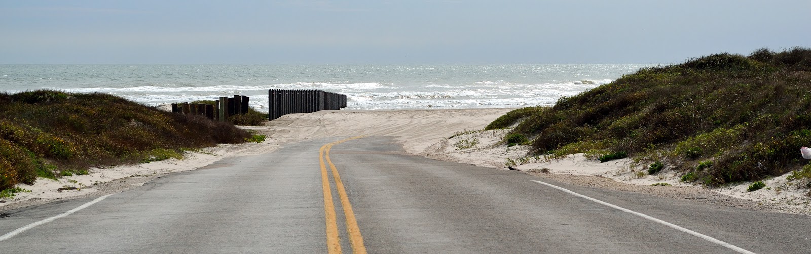
As I continued down the paved road I rounded the corner and came to an abrupt stop. In front of me was one of the most beautiful beaches. Yes, you can travel on the beach in a vehicle. However, beaches in Texas are considered public highways meaning all vehicle have to be street legal and the person driving the vehicle has to be licensed.
This beach can be very remote. The first 5 miles is normally suitable for 2 wheel drive vehicles. South of milepost 5, a four wheel drive vehicle is required. Getting stuck with an incoming tide is not on mine nor Precious bucket list. I did not venture any further than that.
Imagine camping in this solitude. Nothing around for miles. You can camp on the beach or the edge of the dunes for free.
According to the park services, most of the garbage on the beach washes in from the Gulf of Mexico and not from park visitors. Somehow I found this difficult to believe. Vacated campsites where riddled with garbage. People cannot help but leave a carbon footprint.
There are 380 species of birds documented on Padre Island at different times of the year. Before leaving this beach paradise I stopped to shoot some birds that were just hanging out. A Long-billed Curlew and a Royal Tern were both keeping an eye that I didn't get too close.
Just as I was packing up to leave, a vehicle flew by me scaring all the birds and me. I called him/her a few choice words than realized who it was.
Border patrol. Yep that would be them. I forgot how close we are to the border.
As I was leaving the park I saw an old building that needed to be checked out. A sign indicated that you couldn't enter, so I didn't. There are plenty of rattlesnakes in this area. The Novillo Line Camp is the last historic place within the National Seashore that reflects human use and occupation on Padre Island. This camp was the northernmost line camp used by the Dunn Cattle Ranch in the late 19th and early 20th century.
There's talk about restoring it for historic purposes but that has not happened yet. For now it sits as a reminder of years past.