Showing posts with label National Park. Show all posts

Wednesday, October 2, 2024

Indiana Dunes National & State Park, Chesterton Indiana

Visited: 1 - 3 October 2024
Nights Stayed: 2 nights

We left home on route to Amana, Iowa but our first stop was Indiana, an area known for it's 45 miles of pristine shoreline along Lake Michigan. Also well known in the area is Indiana Dunes State Park (which is where we are camping) and Indiana Dunes National Park.

Firstly, Indiana Dunes State Park is surrounded by Indiana Dunes National Park. The state park consists of over 2,100 acres of beautiful pristine and historic landscape. In the early 1900 the area was recognized for its potential thereby being established as a state park in 1925. Large sand dunes located beyond the shoreline have taken thousands for years to form.

The state park which is open year round has a campground with 140 campsites offering both primitive or sites with power. The visitors center has natural and historic displays, an area for observing birds and other critters. The park also offers more than 16 miles of hiking and biking trails.
Our campsite #36
Visitors Center
Large sand dunes
Beautiful Lake Michigan
Beautiful Lake Michigan sunsets
Indiana Dunes National Park, a federally administered park consists of over 15,170 acres and spans across 15 miles of Lake Michigan shoreline. The NP is located about 50 miles southeast of Chicago. It was established as a national lakeshore in 1966 but renamed as a national park in 2019.

The NP campground consists of 66 unserviced campsites and modern restrooms with hot and cold showers. It is open from 1 April to 1 November and closed during winter months. With over 50 miles of trails there is an opportunity to explore this ever changing landscape. In many area the huge living or moving dunes are slowly being blown inland burying the forests as they go.
Mount Baldy Beach Trail
Hike Time: .75 miles, 75 feet of elevation gain, about 1 hour
Mount Baldy is 126 feet above the water level of Lake Michigan and is moving inland at a rate of between 4-7 feet per year. The beach sand on the dunes moves when the prevailing northwest wind exceeds 11 km per hour. Because there is no sand collecting on the waters edge this worsens the movement of Mount Baldy. Beach erosion takes away more sand from Mount Baldy than the waves are bringing in. Much of this is caused due to the breakwall built for Michigan City Harbour. The Army Corp of Engineers began feeding the beach in 1974 to try and correct the effects of the breakwall.
Aerial View of Mount Baldy courtesy of NPS
The Mount Baldy Trail Hike in an out and back trail considered to be a moderately challenging route. The trail features a staircase at the start and sweeping views of Lake Michigan near the end. Walking down to the beach on loose sand was a test but coming back up was where the challenge was.

Bailly Homestead, Chellberg Farm, and Cemetery Trail Loop
Hike time:1.6 miles, 2.5 kms 1.5 hours
The Chellberg Farm was established by Anders and Johanna Chellberg whom moved from Sweden to this area in 1863. In 1869 they purchased 40 acres of land thereby creating the homestead. In 1874 an additional 40 acres was added. The brick farmhouse was built in 1885 after the wood framed house was destroyed by fire 1884. They were the first of 3 generations to live on this land. 
Continuing along the trail we found the Bailly Homestead which was declared a National Historic Landmark in 1962. This was the home of French Canadian fur trader Joseph Bailly from 1774-1835 who was one of the earliest settlers in northern Indiana. Bailly was an independent fur-trader who's business spread from Montreal to Louisiana. 
The Bailly Cemetery is located 3/4 miles away from the homestead on the edge of a sandy ridge. In 1827 Joseph Bailly chose this area for the resting place of his young son. The entire Bailly family is interred in this cemetery.


A Century of Progress - 1933 World's Fair Homes

I bet you are wondering what Indiana Dunes National Park and the 1933 World's Fair has in common...well let me tell you the story. In 1933 the World's Fair which was held in Chicago was called the Century of Progress. It was meant to offer people who were in midst of the Great Depression hope through futuristic changes. The houses were built in such a way they demonstrated modern architectural design, experimental materials, and new technologies such as central air conditioning and dishwashers. In 1935 real estate developer Robert Bartlett bought 5 homes from the homes and industrial arts exhibit at the world's fair. Four of these homes were transported via barge to their new location across Lake Michigan to Beverly Shores, a resort community he was developing. The fifth house was dismantled, trucked to Beverly Shores where it was reassembled. Today, the structures are leased by Indiana Landmarks from the National Park Service, then subleased to people who have restored them in exchange for long-term leases.
The Florida Tropical House was the only state sponsored Century of Progress home, it was commissioned by the state of Florida to lure tourists to "the Sunshine State". The centerpiece of the house is the two-storey living room with an overhanging balcony. The original residence cost $15,000 to build.

The Armco-Ferro House was manufactured for $4,500 by Insulated Steel Inc for American Rolling Mill Company(ARMCO) and the Ferro Enamel Corporation. This was the first to be constructed using frameless steel construction and an exterior of vitreous enamel. It only took five days to construct the 2,400 square foot from prefabricated panels. This home could be mass produced and also be affordable for an American family.

The Wieboldt-Rostone House showcased an exciting new building material that "never needed repairs". The material composed of limestone, shale, and alkali. However, the lake effects of snow, wind, and rain proved to be to much for the Rostone causing severe deterioration by the 1950's. The Rostone has subsequently been covered with Perma-stone, a popular concrete stucco.
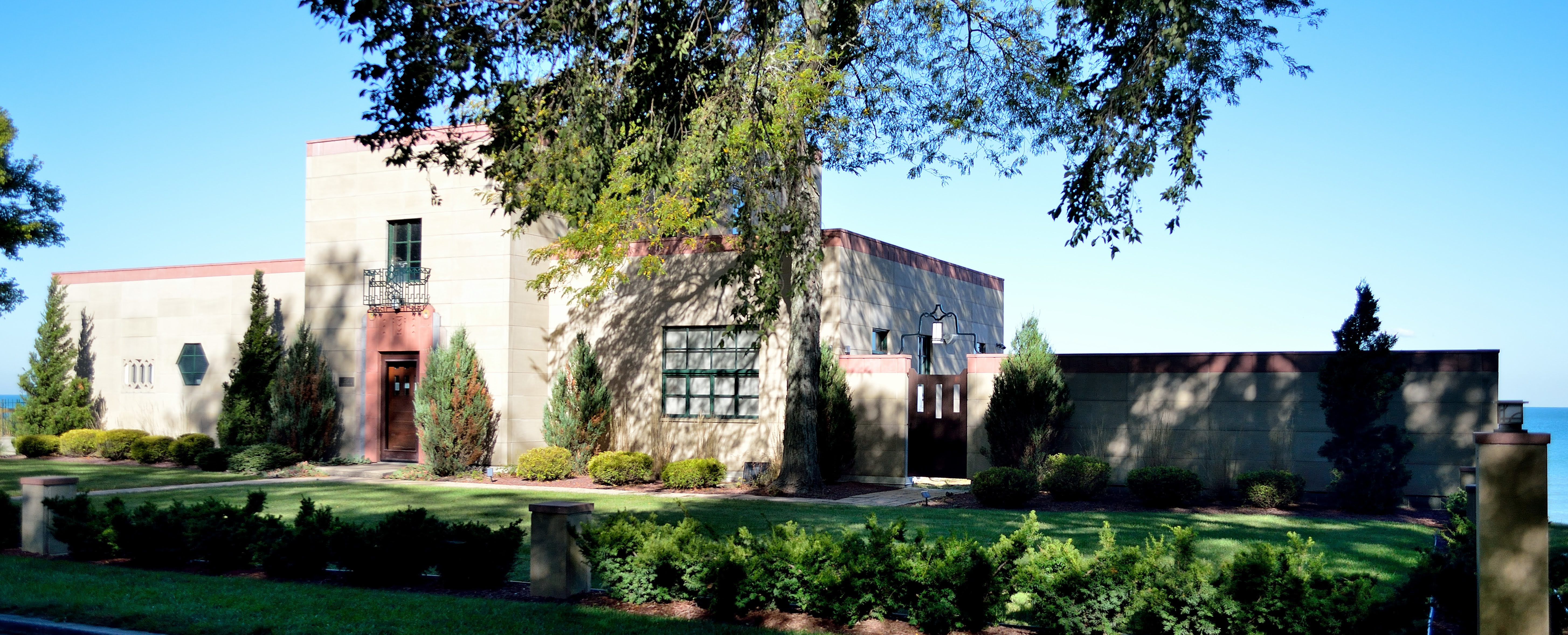
The Cypress Log Cabin was unlike the other ultra-modern homes made of steel, stone, and glass, it showcased cypress logs which are resistance to water and decay. The architect  showed the wood's versatility and durability by incorporating cypress siding, shakes, structural timbers, walls, flooring, and furniture.

The House of Tomorrow's first floor was designed as a service area, originally containing the garage and an airplane hangar. The second and third floors clad in glass contained the main living spaces and a solarium. Because of the floor to ceiling windows the heat loss during the winter months was negated by the solar heat gain reducing the need for mechanical heating. However, the heat gain during the summer months was too great for the air-conditioning and it failed. When Bartlett moved the building he replaced the windows with operating ones to allow air-flow.   

Indiana Dunes State Park and National Park did not disappoint. With the copious trails to hike, the beautiful beach to walk, the numerous historic buildings to explore, and to end the days with gorgeous sunsets to enjoy, we will make this place a regular stop.
If you enjoyed this blog please feel free to leave a comment or follow my blogs.

Saturday, August 11, 2018

Day 76 - Edmonton, AB

These days it seems to be all about the driving from one campground to another. Not what I really wanted to do. When there is so much smoke in the air it just makes it less enjoyable to be outdoors and more sense to drive out of it.

I have never been in Jasper before, so this is going to be a first. The drive was great no real hills or valleys and the road was absent of potholes. Nice.

If I have learned anything from my travels in the Yukon and Alaska its when you see cars on the side of the road you slow down because you know there will be wildlife. Sure enough, there he was a big male elk on the side of the road just minding his own business. You can see the smoke in the background.

We watched as he trotted along side our truck and fifth wheel only to continue on down the road. People were following him.What a nice sighting.

Continuing on down the road through Jasper, we spot female Bighorn sheep and their young. Again, people were being stupid by going right up to them. I stayed in the truck and got great pictures.
We arrived in Edmonton set up camp, then I took the dogs for a long, long walk. Thankfully there was no wildfire smoke in the air. I can breath again, yea. 

Friday, July 20, 2018

Day 54 - Exit Glacier, Seward, AK

After 3 wonderful days in Homer it was time to move on to our next destination, Seward (pronounced Soo-word) Alaska. We barely got down the road when I spotted someone pulling off the road and stopping. That always means some sort of wildlife is present. And sure enough there was mama moose and her two babies. It's going to be a great day.
Seward is situated at the head of Resurrection Bay on the Kenai Peninsula. It is surrounded by snow-capped mountains which are blanketed with lush green vegetation, trees and wild flowers. It has the only deep-water, ice-free port with rail, highway and air transportation in Alaska. 

In 1792, Russian explorer Alexander Baranof arrived by boat and is responsible for naming the port Resurrection Bay.
Seward was founded in 1903 and named after William Seward, who was instrumental in the purchase of Alaska from Russia in 1867. Seward had been a member of Lincoln's cabinet. After Lincoln's death, and the Civil War ended, the U.S. finished the transaction for pennies on the acre.

We arrived in Seward in really good time and it was a beautiful afternoon. I wanted to take advantage of the day so away we go to Exit Glacier which is not far, maybe 10 miles one-way.
Kenai Fjords National Park was created in the 1980's to protect the Harding Icefield and the nearly 40 glaciers that flow out of it. Many of the glaciers reach the ocean in fjords that can only be accessed via the water. Exit Glacier is the easiest glacier of the group to access and the only part of the Kenai Fjords NP accessible by road. The trail to the glacier outlook is just over 1 mile one-way. It starts flat then you start to climb. It's not all that difficult. There is a more strenuous climb to the icefields which is 8 miles long. You definitely need bear spray on the trail.
Exit Glacier Nature Center

Exit Glacier from the road
At the height of the last ice age, about 23,000 years ago Exit Glacier filled the valley. Today, this once massive glacier is retreating rapidly. In the last ten years it has melted back almost 1,000 feet.
Looking behind me at the mountains
The gravel outwash plain from glacier melt
The trail
Lush green mountains
Picture of Exit Glacier in 2004
Photo Courtesy of  the National Parks
Picture taken in 2010 - Exit Glacier receding
Exit Glacier Up Close
Exit Creek and Flood Plain
Another wonderful day filled with wildlife and adventure. Time for something to eat. All this walking has made me very hungry. It's fresh halibut done on the grill tonight. Yummy!

Friday, July 6, 2018

Day 39 - Denali National Park, Alaska

We drove to our next campground called Midnight Sun RV Park in Healy, AK. The day was a mix of rain and cloud. I don't really care at this point, I'm just so excited to get close to Denali. First let me talk about Healy and why we chose this campground.
Healy is situated 113 miles from Fairbanks at an elevation of 1,294 feet. This area has everything you need from grocery stores to gas/diesel, to an Ace Hardware, and lots of places to eat. The main industry in Healy is coal. You can easily see the large cranes stripping the overburden on the hillsides in search of precious coal. The mine produces more than a million tons of coal per year. This coal is so valuable because the sulfur content is among the lowest in the world.

As we settled into our new place, I was excited to get started. So we all jumped into our trucks and headed towards Denali which is 11 miles down the road. No sooner did we literally get out of the park and across the road was a mama moose and her young calf. How amazing. We watched for awhile then pushed on. In Alaska or anywhere on our trip so far, whenever someone is stopped on the side of the road you quickly look for wildlife.
The shear beauty of the mountains above and the river below is breathtaking. My pictures don't do it justice but I will try. 
Our next stop going towards Denali is Nenana Canyon and the Nenana River. This river is used extensively for rafting and kayaking. The black bridge is the railroad which hugs the canyon. The winds in the Nenana Canyon can get extremely strong especially in the winter.
As we ride through Nenana Canyon its a series oh my gosh or amazing. There are several pullouts that you can stop for picture opportunities or just to take in the breathtaking views.
We arrive at the entrance of Denali National Park which starts at Mile 237 of the Parks Highway. The main visitor center is accessed 1.4 miles into the park. That is our destination today. But first I can't pass up another picture opportunity.
My favorite to do when I get to a new place is to start at the visitors center. They are the most knowledgeable when it comes to the surrounding area. They can also suggest how to get the most out of your time in the park. And that is exactly what they did. We watched a couple of really great films on the park. Then did a little exploring.
Visitor's Center

Gift Shop and Cafe
Denali National Park is not like most parks, everything is regulated to keep the wilderness wild. They have an elaborate bus system, more on that tomorrow. For today it's all about enjoying the beautiful weather and the park.