Showing posts with label National Historic Site. Show all posts

Friday, August 25, 2023

Day 14 - Battle of the Restigouche NHS

The Battle of the Restigouche was a naval battle fought in 1760 between the British and the French with help from the Acadians and Mi'kmaq. Prior to this battle Quebec City had fallen to the British on September 18, 1759 on the Plains of Abraham. However, the French were still present in New France. Several appeals to France for supplies and reinforcements went unnoticed or neglected.

On April 10 1760 the frigate Le Machault set sail along with five merchant ships carrying provisions and troops from Bordeaux. Finding that Quebec City had already fallen to the British, the French fleet sailed for Chaleur Bay taking shelter in the estuaries of the Restigouche River.

The British sailed from Louisburg arriving June 22 1760 at Chaleur Bay. They blockaded the river causing the French to move further upriver. The Le Machault scuttled some schooners as a barrier and turned broadside. The British were able to move around the sunken ships and confronted the French on July 3 1760.

On July 8 1760, after several days of battle the French commander gave the order to abandon ship and scuttle the Machault. The frigate sank ending the final naval engagement between France and Great Britain to take place in North American waters.
Blue is French & Red is British
After 200 years of being underwater archeologists were able to recover over 7,000 pieces of artifacts from the Machault between the summers of 1969 and 1972. Some of the hull pieces were well preserved and consequently recovered because of the muddy waters they were in.
The Stem
The orange represent the recovered part of the Machault in lower pics
A wool stocking, wool hat, leather shoe, & wool mitten 
Deadeyes & a cleat
Brass & copper pots with brass colander
Chinese porcelain

Oak barrel with salted pork contents dated 1760
Shoes

French 12 lb, 6 lb & 4 lb cast iron cannonballs marked with the fleur de lys
For a small museum it was extremely well laid out and very informative. We spent about 1-1/2 hours reading and touring around. Excellent Canadian history.
The red chairs are overlooking the Restigouche River where the battle occurred

Thursday, August 17, 2023

Day 6 - A Lighthouse, Submarine, & Hike

Today takes us to Site historique maritime de la Pointe-au-Pere in Rimouski. Our first stop is the Pointe-au-Pere Lighthouse which is a Parks Canada NHS however it is managed by the maritime museum. Along with the lighthouse, there is a submarine, and a pavilion with artifacts and stories of the Empress of Ireland. Since I was on a submarine during my active military days and have visited Halifax's maritime museum we opted for just the lighthouse today.
Even before Pointe-au-Pere's first lighthouse which was built in 1859, several pilots operated from this area offering their services to guide incoming ships. In 1867 the first lighthouse was destroyed by fire consequently a second was built on the same site at a cost of $1600 to $2000. The second was built identical to the first. In 1909, the construction of a more modern third lighthouse rendering the second one obsolete. The lighthouse is 33 meters(108 feet) tall and is built from concrete with eight reinforced concrete buttresses. There is a total of 128 steps which include 2 ladders to reach the top.
In 1975, a fully automated 115 foot fourth lighthouse was erected just east of the third light. In 1976 the jurisdiction over the third transferred from Transport Canada to Parks Canada thereby becoming a National Historic Site. With new GPS and radar systems the skeleton tower was decommissioned in 1988. The view from the top of the lighthouse. Susan opted for the Red Chair below.
We opted not to tour the HMCS Onondaga instead I took some pictures and walked out onto the pier. The Onondaga is a Oberon class submarine built in 1965 in the UK. It was owned by the Canadian Navy and in service for 33 years. During this span it travelled 500,000 nautical miles which is 23 times around the earth. Staff included 68 crew members of these 6 were officers.
After a full morning of sightseeing and a little bit of grocery shopping we headed back to Bic for lunch. After lunch and a little snooze I went for another hike. This trail is the Le Chemin-du-Nord considered an easy out and back 3 km hike. The trail is depicted in red on the map.
The Chemin-du-Nord starts at the Ferme Rioux discovery and visitors center. This is a wide trail composed of fine gravel that follows the coast. The trail is a very popular one due to it's low level of difficulty. Passing by Anse a Wilson people were swimming in the cove...to cold for me.
The shear beauty of this park amazes me. Around every bend and curve it's a wow moment. Wind swept trees from salt water and erosion causes them to die.
In the early 19th century several Englishmen built houses and/or cottages along the shores of Anse a l'Original. The Feindel cottage is one of these houses. The ownership has passed to the park.
The park has a plethora of wild rose bushes
In the 1920's Walter Lyman, a colonel in the Canadian Army acquired 350 acres of land along Cap a l'Original coast. Because of the peace and tranquility they had 5 structures built, a cottage, boat house, stable, sauna, and wood shed all with no electricity or running water.
The view to the east from the Lyman cottage deck...it is breath taking.
Continuing along the very flat trail with tall pines overhead. It's nice because when the sun broke through it was hot.
Reaching the end of this portion of the trail was breathtaking. Large rocky cliffs meet the water can't get any better than that. If you are an experienced hiker you can continue around the Cap-a-l'Original but it has to be started an hour before low tide. The trail is not marked, has steep dangerous cliffs, and rocks to climb over. Nope not for this girl besides it's not low tide. Yeah
Another hike in the books, what a great day. Last day tomorrow at Parc National du Bic, I will have to see what is in store, a bike ride, hike who knows...I will decide in the morning.

Wednesday, June 20, 2018

S.S. Klondike National Historic Site, Whitehorse YK

Natives from Asia were the first to use the Yukon River to explore the interior after the last ice age. They settled along the river and used it for fishing, trading, and transportation.  In the early 1800’s Russian fur traders were the first white men on the river. They established settlements on the coast of Alaska and then pushed into the interior 1000 km or 600 miles. The Hudson Bay company traders began fur trading along the river in the 1840’s. The Americans purchased Alaska from the Russians in 1867. Soon thereafter, steamboats were introduced to the lower river. Gold was discovered on Bonanza Creek in 1986 near Dawson Creek, Yk. Two hundred and fifty sternwheelers worked the Yukon River from the late 1860’s until the mid-1950’s. The early sternwheelers were smaller but they could carry 200 to 250 tons of supplies with a draft of 1.3 metres or 4 feet. Many pushed barges at the same time to increase their cargo capacity. The S.S. Klondike is a National Historic Site so I had to check it out and it was so worth it. It's late June and the Lilacs are just at full bloom.
The original S.S. Klondike was launched in 1929 to transport ore to Whitehorse. She was a revolutionary design since the cargo capacity was 50% greater than the largest boat on the Yukon River. Unfortunately, in 1936 while in the hands of an inexperienced pilot she struck a reef in the river and sank. Today’s S.S. Klondike was launched in 1937 and was an almost exact copy of the first. She had two careers, the first as a cargo ship and the second after 1952 as a tourist cruise boat. She was retired in 1955, as the last sternwheeler on the Yukon River.
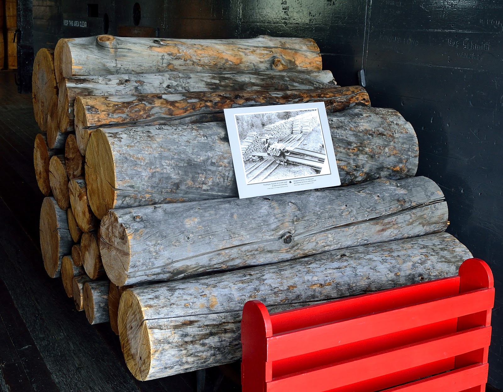
The distance between Whitehorse and Dawson City is 740 km. Time and fuel differed depending on if the journey was up or down stream. Downriver would take 1.5 days with 1 - 2 wood stops and burn 40 cord of wood. Upriver would take 4 - 5 days with 5 - 7 wood stops and burn 140 cord of wood.
Being a much larger boat you would think she would sit lower in the water. Nope she had a draft the same as the smaller boats...1.3 metres or 4 feet when fully loaded.
The Atlin is the only known survivor of the many wooden barges that once worked the Yukon River. It was built in 1934 and worked on Atlin Lake moving mining equipment, food, supplies, and the occasional tourist. The large sternwheelers while fully loaded with cargo could push 2 - 3 barges fully loaded at the same time. 
I toured downtown Whitehorse finding several other museums and attractions that caught my eye. The Old Log Church was built in 1900 and served as the Anglican Cathedral for Yukon.
The Kwanlin Dun Cultural Centre was built on the river because the the name means "people of the water running through canyon. The centre had some amazing artwork.
This immense slab is Yukon's largest copper nugget at a weight of 1175 kilo or 2590 lbs. It was found in 1905, 250 miles north of Whitehorse.
Evidence of the once booming rail traffic through Whitehorse. Most of the tracks have been taken out but some still remain in the downtown area.