Sunday, April 6, 2014

Where's the Toadstools

The toadstool trail is an easy hike that follows a sandy wash and ends at several beautiful rock formations. The trail head is just off Hwy 89 and continues for 0.8 miles one way. The total elevation gain is 100 feet with no shade therefore hats and lots of water are a necessity. We decided to go early to avoid the heat of the day.
Susan choosing her steps carefully
What's a toadstool you ask! It's a spire-like feature with a boulder perched on top of a pedestal rock. They form when boulders from the higher Dakota Formations fall downward onto the softer Enstrada Sandstone. This softer sandstone is now sheltered from wind and water lessening the effects of erosion.

A future toadstool
Pretty cool toadstool
Eventually the weight of the boulder on top will be too much for the softer sandstone underneath and it will collapse.
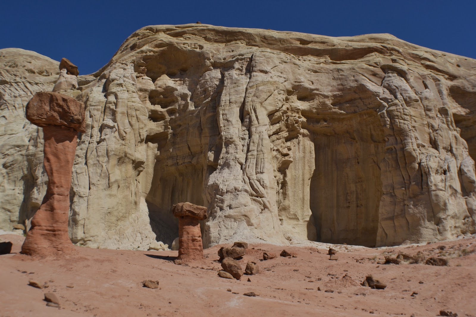
More toadstools...and some that have collapsed
The white sandstone is very soft and will erode and collapse under weight.
Looks like a chicken to me
Erosion resulting in these future toadstools
Softer sandstone washing down the rock face
As we started our walk back, we couldn't help but think that in 5 or 10 years how different this place will look. Through wind and water, the forces of nature can be unstoppable.
How different will this look in 100 years

Saturday, April 5, 2014

Upper Antelope Canyon

Before we left Page, AZ both Susan and I wanted to visit Upper Antelope Canyon. Why and what is so special about this place. Well, because it is on the Navajo Reservation you need to book with one of the many tour groups in town. We went with Overland for no particular reason. The walking part through the slot canyon is about a half mile but the ride getting there rattled my bones.

The Navajo gave Upper Antelope Canyon the name of  Tse'bighanilini which means "the place where water runs through rocks". The canyon walls rise 120 feet from the stream bed. The canyon was formed by the erosion of Navajo sandstone mainly due to flash flooding. At this point I am going to let the pictures tell this fascinating adventure.
Just inside the entrance...lower right corner someone waiting to come in...gives an idea of how big this canyon is


Looking up the sun hitting a tumble weed stuck in the cravats
Appears as a wave
Sun shining in on this wall
The rock looks like it's bleeding


The shadow looks like Monument Valley


Leaving the canyon
The guide we had was wonderful in helping us set our cameras to get the best pictures. Thanks Vivian. All in all what a wonderful experience.

Tuesday, April 1, 2014

Page, Arizona

Leaving Zion was bitter sweet. Yes we wanted to stay a few more days but our site was booked for someone else who wanted to have the same pleasures as us in Zion. So instead of moving sites we decided to push on to Page, Arizona. Where! That is what Susan said when I told her our next destination. Then I explained to her all the things you can see and do, now she's on board. Page began over 50 years ago as a construction camp for workers on the hydroelectric project. Because the land was owned by the Navajo  an agreement was made to transfer 16.7 square miles to the BLM in exchange for an amount of desirable land in Utah. Completed in 1966, the Glen Canyon Dam stands 710 feet tall and produces enough energy to serve 1.5 million users. The bridge was completed in 1959 allowing trucks to deliver material for the dam and the new town of Page.
Glen Canyon Dam & Glen Canyon Bridge
When the dam was completed water began backing up behind the great wall. It took nearly 17 years to reach "full pool" and established over 1,900 miles of shoreline with a depth of more than 500 feet in areas. Lake Powell was born.
Lake Powell
A playground for nearly three million visitors annually
Lone Rock
The sun was out, having lunch while overlooking Lake Powell, and taking pictures can't get any better than that. Oh yes it can. After lunch we went back to the dam for one last look and what do we see flying above our heads but a California Condor. Of course my long lens was back in the rig, so we just stood and admired how beautiful it was.
Looking below the dam at the Colorado River...somewhere down there the Condor landed
Above the dam is a wonderful hiking trail called Hanging Garden. It's flat, easy to follow, one mile out and back, and your rewarded with a hidden oasis. Hanging Garden is a Navajo Sandstone overhang where water seeps from the walls to provide the right conditions for Maidenhair fern to grow.
Standing under the overhang was noticeably cooler
A must thing to see if your in the area and it's free is Horseshoe Bend but beware it's not for the faint of heart. With a drop of a 1000 feet straight down with no guard rails to prevent you from going over, and if you can get close enough, you are rewarded with a beautiful view of the Colorado River.
Horseshoe Bend
Not being afraid of heights I got close enough to take the picture. I have to admit being this close gave me the goosies. Then I got really freaked out when a girl sat on the edge with her legs dangling over. I just walked away, it almost made me sick. 

The Grand Stair-Escalante National Monument (GSENM)was established in 1996 and is overseen by the BLM. Spanning nearly 1.9 million acres of high, remote, and rugged regions, you will find the last place in the continental United States to be mapped. We went to the GSENM visitor center to see the dinosaur displays and to get an idea of trails to hike. The exhibits were amazing and better yet it is also free. We had a guided tour by Merle Graffam whom discovered a new dinosaur species in the GSENM in 1999.
Dinosaur bones discovered in BSENM 
With bold plateaus and monstrous cliffs you have to wonder how much more is out there to discover.

Sunday, March 30, 2014

Angel's Landing

The one trail that everyone talks about in Zion is Angel's Landing. The day before we left was that day. Yes it's Angel's Landing day. Remember people have died climbing it but then again people have died crossing the road. With Susan's blessing and a be careful, out the door I went. Am I nervous, hell no, more excited than anything. I park Precious(my truck, yes that's her name)and away I go. As soon as you get across the river you start a gentle climb, then it gets a little steeper and a little steeper.
Looking back at the trail...A good climb so far
If you weren't breathing heavy by now a series of switchbacks will test your lungs and make your legs burn. I can't ever remember feeling like this when I ran all those marathons. I haven't even got to Walter's Wiggles yet.
These were tough I have to admit
The trail does flatten out on a few occasions allowing time to get use to the higher elevations and to catch your breath.
Don't get close to the edge... it's straight down
Obstacles
Nice rock formations


This gentle part quickly ends when I got to the infamous Walter's Wiggles, a series of 21 quick zigzag switchbacks.
Walter's Wiggles
After conquering the wiggles, I reached Scouts Landing and a much needed rest was required before I ascended to Angel's Landing. Many people turn around at this point and there is absolute nothing wrong with that. As I got ready to go a really strange feeling came over me. Something I haven't felt in a long, long time...fear. As I watched others go up today was not the day that I would be going.
Chain holds help you navigate the trail up
At the end of the tree branch is Angel's Landing
As I watched people come and go I knew I had made the right decision. Enjoying the view of the canyon below and the mountains above was almost heavenly.

Thursday, March 27, 2014

...more Zion

As I said in my previous blog, I'm not sure how it gets better than this. Well it does. With every new trail we explore the scenery changes but then again it doesn't. Does that makes sense. Anyone that has explored Zion probably knows what I mean. It's a continuous series of "wows" and "look at that". That being said we decided to stay in Zion to hike as many trails we could. Yes, we could have ventured to Bryce Canyon or The Arches but decided to save that for another time. At this time of the year we didn't have to wait for a shuttle, vehicles are allowed into the canyon until beginning of April. We are taking advantage of that.

I was going to do the Angels Landing but some well laid plans did not work out. I woke to a light snow on the mountains and generally a nasty day in the higher elevations.
Fog and snow in the hills...not an Angel's Landing Day
It wasn't raining or snowing in the canyon so we decided to venture out. What ever trail sparked our interest that is the one we would do. People were driving so fast to get to their hiking trail they missed this wonderful mule deer feeding on the side of the road.
Breakfast
At the end of the road lies The Riverwalk which is a 2 mile paved trail out and back. As the name indicates it follows the river on a paved path that ends at the start of the narrows. It's upstream where the Virgin River narrows and is confined within the Navajo sandstone creating a tight perpendicular gorge. Downstream the softer Kayenta Formation rock is undercut by the fast flowing river.
That water was sooooooooooo cold
After lunch we decided to also hike Canyon Lookout since it turned out to be such a wonderful day. Hopefully we might get lucky enough and see bighorn sheep. The trail lies just beyond the Zion-Mt Carmel Tunnel. Did someone say tunnel I didn't tell Susan until we were almost there, she does better not knowing. Prior to the tunnel we were rewarded with a view of The Great Arch.
The Great Arch
Getting to the arch and tunnel is a 3.6 miles long road consisting of many switchbacks with drop offs on one side and a mountain wall on the other.
Looking back at Zion-Mt Carmel Highway
Construction on the highway and tunnel began in 1927 and was completed in 1930. Because the tunnel was built in the early years when vehicles were not as big as the ones today, there is a height restriction.
Waiting at the tunnel for a large bus to come through
Parking at this trail head is at a premium and there appears to be a few people taking advantage of the day like us. Walking along the trail you couldn't help but notice the beauty of your surroundings.
Spring has sprung
A plank bridge with nothing below
We continued along keeping a sharp lookout for big horn sheep but I have the feeling they didn't like all the yelling and crying kids on the trail either. Getting to the end was wonderful as we sat on top of the Great Arch looking down on the canyon below.
No big horn sheep here
The return trip was a little easier since it was down hill most of the way. I always told Susan that it doesn't have to look pretty just as long as your enjoying yourself.
It ain't pretty but we had a good laugh

Tuesday, March 25, 2014

Zion National Park

Spending a full week in St George was wonderful but it was time to move forward. Our destination is Zion National Park and within minutes of arriving I knew this is where I wanted to stay. There are rare places when I put my camera away and enjoy the surroundings, Zion is one of those places. But in saying that I did manage to take a few (only 500) so I will share the beauty and our adventures. Like always we had to get set up. We chose Zion Canyon RV Campground with help from our good friends Nancy and Betsy.
All set up know one around us life is good
I decided to venture out on my bike to check out the park and surrounding area. It didn't take long to look through the park as it's quite small but the backdrop is beautiful.
Having coffee each morning looking at this
The view from our back window
I sat beside this stream enjoying the peacefulness
Springdale is the small town just outside of the National Park. It's small but it's mighty having just about everything you need without going to the big city. There are places to grocery shop, tons of eating establishments, loads of hotels/motels, even a spa for after those long hikes and of course plenty of souvenir shops. It was still really early in the day and Susan wanted to get a hike in before the day ended. We decided on Lower Emerald Pools for our first hike.
Yes, I've created a monster she loves hiking
The pathway is paved to the lower pools with some steep parts. There are three sets of pools on this trail, all providing a year round habitat for a large variety of plants and animals. The upper is a moderate hike and the middle is closed for reasons I don't know. I'm not sure what I was thinking, I had thought it was going to be a nice quiet hike with very few people. Wrong! We continuously had people around us, so much for serenety. Continuing along we came to a beautiful waterfall pouring over the rocks. If it was a really hot day it would be wonderful but not! Yes we got a little wet. The rock ledge above the waterfall is harder and more resistant than underlying formations. Over long periods of time the softer lower canyon rock layers have slowly eroded away creating the 100 foot drop and the waterfall you see below.  
Water falls pouring down into the canyon
Some of the beauty along the path spring has sprung

Feeling good and wanting more we checked the time and our water supply (had enough) we continued on to the upper pools.
Lot more difficult but we took our time
It was so worth the extra mile hike. The scenery was stunning. Being able to sit and enjoy the canyon from one place.
Looking down Heap Canyon with the Virgin River in background
Virgin River running through Zion Canyon
It took us almost 3 hours to complete and we were spent not so much physically but mentally. I don't know how it's going to get any better than that. The scenery was stunningly beautiful.
Picture perfect scenery