Tuesday, February 11, 2014

Apache Trail

In doing my research about the Phoenix area I came across a driving tour called the Apache Trail. The trail starts in Apache Junction and is 50 miles long, 21 miles are unpaved. My research indicates that depending on how many times you stop it can take half a day or longer. Sounds fantastic to me so away we go.
Apache Trail Map
When we got to Apache Junction we decided to go clockwise on the trail. A very very good decision by us, you will see why later. In the early days the trail served stagecoaches and freight wagons. More recently test drivers from GM Proving Grounds used the trail to test tires and vehicle maneuverability. Okay.......this trail really peaks my adventurist side.

Our first stop was Lost Dutchman State Park. I had heard many great things about the park so I wanted to check it out for myself. And it's all true, what a fantastic place. Tons of hiking trails from easy to extremely difficult and lots of wildlife/birds. The campground has water/electric and a dump station. What more could you ask for.
Superstition Mountain in the background
As we continued down the trail, better known as US 88 the road is nicely paved and quite well travelled. It twists and turns through the mountain above the lakes and rivers.
Trails leading off to who knows where
About 15 miles past Lost Dutchman Park is Canyon Lake. The lake was formed as a result of the Mormon Flat Dam which was built in 1923. The lake now has several marinas and an RV Park. Not sure if I would want to tow the rig up here even though the road is paved.
Down river is the Mormon Flat Dam
Canyon Lake
Continuing on we get to the "town" of Tortilla Flat with a population of 5. It appears to be the place to rest before continuing on. Tortilla Flat started as a stagecoach stop in 1904 and became only one of two stops along the trail. Unfortunately the town burned to the ground in 1987 but was rebuilt. Now it features a saloon to get burgers and a store that serves prickly pear ice cream. Yum. This is the place to stock up on all the necessary items like water and snacks for the rest of the trip. There is nothing after this. Oh yeah make sure you start with a full tank of gas, their is none along the way.
The town of Tortilla Flat
Electricity back in the day
Original schoolhouse


Beautiful mountain view from Tortilla Flat
Okay so we arrive at Fish Creek Hill and this is where decisions are made to continue on or turn back. Of course there's no turning around for me, we still have a few more miles of pavement left before we get to the switchbacks, steep descents, and dirt road.
Canyons atop Fish Creek Hill
 
It's a long way down if you fall

As we looked out over the canyons admiring the view we see the dirt road that we are going to take. I look at Susan she looks at me with at really scared look on her face. I give her my confidence speech and away we go. Just remember the following pictures you see are real, I have not adjusted them. Oh, did I mention the road is two way.
The start of dirt road, no barriers
We are descending into Fish Creek Canyon


As we are descending into the canyon people are passing us going the other way. My suggestion is if you decide to do this trail go the same way we did. At least you have the mountain side when cars pass not cliff side.
Nice guard rail
I'm trying to keep Susan occupied by taking pictures, there is no where to stop on this steep descent.
Great, one lane can't see anyone coming
Many of the turns along this part you can't see anyone coming. You just hope they are on their own side.....which just happens to be your side.
I have full confidence in those guard rails...yeah right
 
Many cars did pass us going the other way
There's not much opportunity to sight see if your the driver. Eyes on the road at all time. I can't imagine doing this drive when it rains.
There are a few places to pull off, Susan was adamant we did not
You don't need a 4X4 just a really good reliable car. Actually, doing it in a pick-up is worst since the back end is very light. I found myself fishtailing many times towards the cliff. We reach Fish Creek at the bottom and now we have to go up the other side. Susan is looking a little pale, very scared, and not happy at all. Hence, you will notice their are no more pictures until we get to flatter ground.
The rock formations were stunning
I was able to stop and take some picture
At this point we are about half way on the dirt road. Apache Lake is a man made lake which was formed as a result of the Horse Mesa Dam in 1924. The lake has boating, fishing, camping, and a restaurant. Yes camping, how they got their rigs, motorhomes etc. here I have no idea.  I sure wouldn't pull a rig up here.
Apache Lake
It's 11 miles from here to Roosevelt Dam on the same type of dirt road with switchbacks and potholes. However, the only difference for us is there are no pictures. Susan has joined the white knuckle crew she just wants to see pavement.
 
We reach Roosevelt Dam and I could see a big smile and color return to Susan face. The first stone in the building of Roosevelt Dam was laid in 1906 and took 5 years to complete. Blocks of stone were carved out of the canyon walls and hoisted into place using a block and tackle system.
Roosevelt Dam
Between 1989 and 1996 the dam was modified at a cost of $430 million. They used 450,000 cubic yards of concrete and 849 miles of reinforce steel which ultimately increased the height by 77 feet. This allowed retention of more water in Roosevelt Lake.
 
A bridge had to be built prior to dam modification being done. The Roosevelt Lake Bridge, built in 1987 is the longest two-lane, single-span, steel arched bridge in North America.
Roosevelt Lake Bridge
We are now on paved roads but have at least an hour and a half drive to get home. It's a long day but so worth it.
Last shot, time to go home.....the moon is out already

Sunday, February 9, 2014

Casa Grande RV Resort, Arizona

After being here a week I figured I should write something about the park better known as Casa Grande RV Resort. Well, where to start. Firstly, I decided on this one many months ago because of the rave reviews it received on RV Parks Review. After camping in literally 100s of campgrounds I swear by this site to give me another great place to stay. This place is truly a resort and winter destination.
Entrance to Park
We arrived early but that's okay with them, they had our names along with many others on the board welcoming us aboard.
Staging Area
From the check in to within minutes of arriving we felt at home in this park. The staff were friendly and accommodating. Our neighbor welcomed us as well inviting us over for a beer. The first site they gave us was too narrow so I called the office and "no problem Mame take the site 2 down". I guess this is where their motto comes into play...."the costumer is always right".

There's 2 sections to the park. One where the sites are a little closer and then our area where you have more space between rigs. It's all gravel except for a nice concrete patio beside your rig. No tables at any of the sites, how unusual.
Not our area but nice
The park has what looks like brand new cottages or what I call park model homes you can rent for the season or by the week.
New park model cottages
There are so many amenities hence the resort status this park gets. They have a full lending library, several gaming & social rooms, clean bathroom & shower area, an exercise room, 4 billiard tables, 2 pickle ball courts, 2 heated pools & a spa, a large dog park, laundry room, and more.
Library & Restrooms
Well stocked library
4 Pool tables
Shuffleboard & Ping Pong


Lots of washer & dryers here

Nice exercise room

Meeting Rooms
Two well maintained & used pickle ball courts
When we checked in we went through all the what's happening in the park and given a weekly menu. A what....a menu. Yes that's right they just hired a new chef whom prepares nightly feasts at a cost between $6 - $10 per meal. Meals include prime rib, all-you-can-eat pasta night, chicken cour don bleu, and many more. This is up and above the free waffles, juice, & coffee each morning. I'm loving this place.

After saying all these wonderful things about this park there is a downside. We were backed up to the busiest road in all Casa Grande. The traffic was nonstop all day every day. The only time it was quiet is between 3 - 4 in the morning. Continuous ambulances & fire trucks along with WalMart truck up and down the road. The sites in the other part of the park, not so bad not so noisy.

With saying that the sunsets each night were spectacular (if you looked between the vehicles).
Taken out our back window

Thursday, February 6, 2014

Goldfield Mine Ghost Town

On top of a small hill between Superstition and Goldfield Mountains is an old settlement and tourist attraction called Goldfield Mine Ghost Town. This once booming town got it's start back in 1892 when a very rich high grade gold ore was found.
Goldfield Mine Entrance
The high quality of gold ore found and the legend of the Lost Dutchman Mine caused miners to flock to the area seeking their fortunes. Five years after the boom started the rich vein of ore dried up. Miners packed up their belongings and left Goldfield as a ghost town.
Today tourists can pan for gold

In 1921 a man named George Young had the hopes of finding gold in the once prosperous mine. He reopened the mine using new equipment and methods. But finally after five years the gold was gone, the mine was closed for good, and the town died again. Today the town has been reconstructed to look like an authentic mining town with shops, livery, saloons, and more.
A couple of shops on the main street
We will wait until after lunch to try the bakery
The livery making cool things
All this walking and sightseeing is making us very hungry so we decided to go to the local saloon for lunch. I was determined not to have my usual a burger.
The Mammoth Saloon
The interior of the building was pretty cool decorated in western style.
Real western theme
Saloon entrance
Waitress


Old timer playing the fiddle while we eat, he was good
The view from our table...Superstition Mountain...Awesome
I went with the fishburger
With very full bellies and unable to eat one more morsel of food we left the ghost town behind. What a fun experience.

Wednesday, February 5, 2014

Superstition Mountain Museum

The Superstition Mountain Museum is a collection of artifacts & history from Apache Junction and surrounding area. The museum gets it's name from the backdrop of the 160,000 acres rugged Superstition Mountain Range located in Tonto National Forest. It's a beautiful day the sun is shining so we decided to walk the outside part of the museum. Susan sees a sign about rattlesnakes she does an about turn and heads back to the truck. I convince her that I will protect her from those big bad snakes so away we go. If she only knew.
No snakes yet
The museum consists of 12.5 acres of original and reproduced artifacts from 19th century living.
Windmill
Shovel used on Apache Trail


The early 20th century saw many individuals living on rural farms and ranch land making it difficult to transport large steam powered equipment. The quest for clean uncontaminated water was essential for living in these remote areas. An inventor named Seth Powers would create such a product. This improved drilling machine was livestock driven and could be transported to vast rural areas. It could bore 60 feet per day to a maximum of 150 feet. 
The Improved Powers Well Boring & Drilling Machine
The Apacheland Barn was used in several western movies including the Rifleman series.
Apacheland Barn with Superstition Mountain backdrop
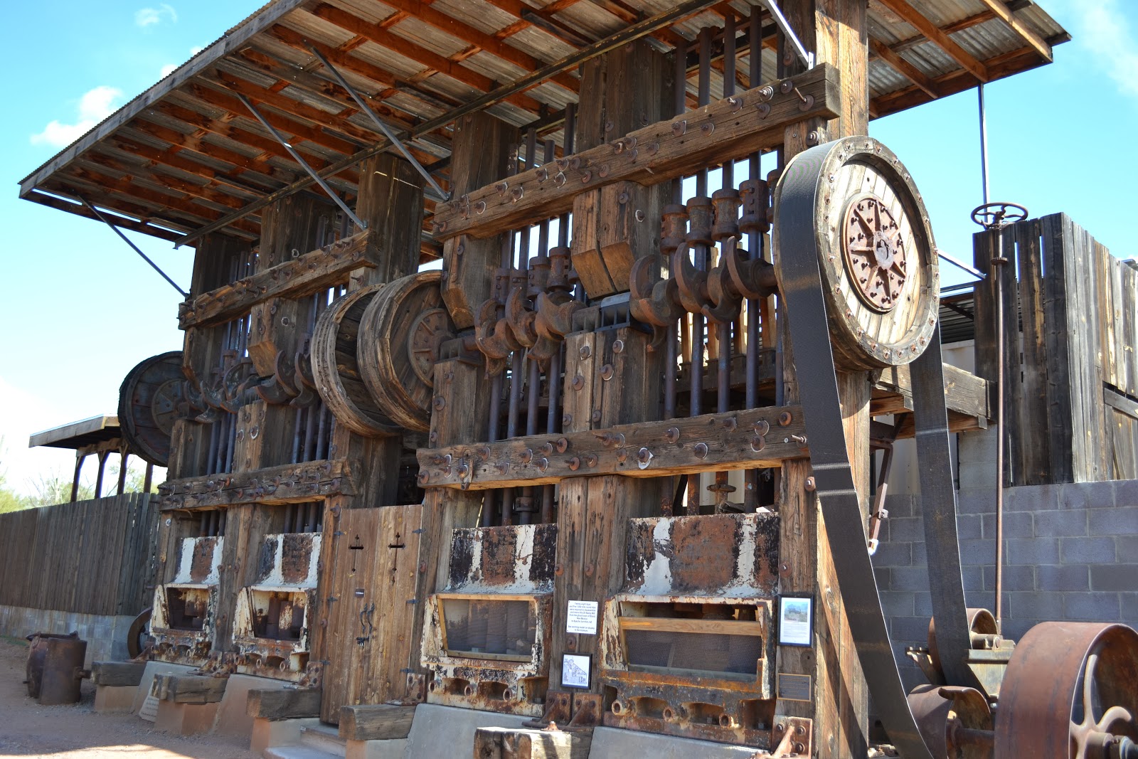
As we continued our self guided walking tour around the grounds we came across a massive machine that we could actually see from the museum parking lot. It's a Twenty Stamp Mill dating back to 1914. What is it you ask. Well chunks of mined ore no larger than a fist is fed into the stamp mill along with water. The 900 pound stamp crushes the ore fine enough so as the gold or silver can be extracted.
Twenty Stamp Mill - 1914
Many of the artifacts on the premises are original some are not. This Wells Fargo Stagecoach is a perfect replica of one used back in the day (me included).
Take me to the nearest saloon partner 

Tuesday, February 4, 2014

Casa Grande Ruins

The Casa Grande Ruins are located in the small town of Coolidge, about an hours drive from the campsite. Anyone that has spent time in the Sonoran Desert knows how harsh this land can be. Annual rainfalls averaging 8 inches and temperatures reaching 120 degrees F. For people living on this land centuries ago, daily chores presented daily challenges. Not only did they lack metal tools and wheeled vehicles they also had no burden animals.

Casa Grande Ruins
The first desert dwelling farmers of the southwest are called the "Hohokam". Irrigation was key to their success in this harsh desert. The Hohokam dug hundreds of miles of canals using stone-age tools allowing them to cultivate corn, beans, squash, cotton, tobacco, and more. This successful agricultural system lead to the building of civilizations, hence the Casa Grande Ruins. These ancient remains were built and used by the Hohokam from the 1200s and 1300s. The Hohokam used a material called caliche to build  their permanent dwellings. These ruins at one time had a 7 foot enclosure wall around the compound.
Several building existed within the compound
The grandest building within the compound was named Casa Grande, it stood 35 feet tall and contained 3,000 tons of caliche.
The remains of Casa Grande
Casa Grande contained beams of pine, fir, and juniper which were obtained from 50 miles away.
A replica of what Casa Grande was like
Researchers have found that the small circular windows in the upper left portion on Casa Grande's west wall aligns with the sun on the summer solstice. The square hole on the right aligns once every 18 1/2 years with the setting moon. Is this a type of calendar system for harvesting crops?
The best preserved wall of Casa Grande
Within a few generations after Casa Grande was built the Hohokam society declined. Compounds were abandoned and by the 1400s the Hohokam society ended. Reasons are unknown as to why this happened but it is thought that years of heavy flooding followed by years of drought damaged their canal system and consequently their crops. Today this is all that is left of a once thriving community.

Sunday, February 2, 2014

Superbowl Sunday

Today is the day. Yes I'm a big football fan and I plan on watching the entire game with few interruptions. Before I can do that it's also a moving day. Who planned this one. I take full blame. The good thing we're only travelling 80 miles down the road. So giddy up lets get going.

Well we're here at the campground, it's 1145 hrs and the site they gave us is not wide enough. I knew that before we started backing in. Anyway called the office got the site two over perfect. Everything is level, hook up hydro, unhook the truck, hook up everything else, and done. Its the countdown 1230 hrs time for lunch, tweak a few things on the rig, and finally a half hour snooze before the big game.

You wonder why I'm so excited, well two reasons. It all has to do with being back in Canada. Every year for my working career as a nurse I had to work Superbowl Sunday and second I love the commercials. They don't broadcast the US commercials until after the game.

Okay it's kickoff got to go. Yes I'm cheering for my boys the one and only Denver Broncos.
 
...........fast forward 5 lousy hours.

That wasn't a game, it was a disaster OMG. I should have worked that game. All I can say is maybe next year Peyton.

Friday, January 31, 2014

Sabino Canyon, AZ

The Santa Catalina Mountain range began their formation about twelve thousand years ago, the same time giant Mammoths roamed this area. Today we are roaming the area called Sabino Canyon.

Sabino Canyon is part of the Coronado National Forest in Tucson, Arizona. Arriving at the park we paid a $5.00 vehicle entrance fee, found a parking spot, and planned our trip. We decided on the narrated shuttle bus ride ($8.00 each) up the canyon. There's nine stops at which time you can get off or on at any time. However, if you come all the way back down on the shuttle you can't go back up. Now we know the rules away we go.
Green is the start, Yellow is the tram route, Red is the end
As we were riding the tram up the canyon I was thinking I would rather have walked the almost 4 miles to the turnaround. The tram seats were so hard and uncomfortable you felt every bump. I'm definitely not taking it back down. I hope Susan feels the same way.

Finally at the top and what a view. Susan was on board with walking back, until she got too tired then we would pick up the tram. But for now I am just soaking in the beauty and serenity.
The turnaround point for the tram at the top
With camera in hand, a lunch bag over my shoulder, and binoculars around my neck, away we go. As we started our descent down the canyon we met many people walking up then passing us going back down. Now that's a workout 8 miles round trip.

In 1887 an earthquake centered in northern Mexico caused massive rocks to crash down and come to rest on the valley floor.
Valley Floor
In the 1930's CCC workers built bridges and 4 miles of road through the canyon into the mountains. The intent was to build a road to Mt Lemmon but the terrain was too difficult to proceed. Today the road ascends from 2800 feet at the visitors center to 3300 feet at the tram turnaround.
Susan walking over one of nine stone bridges
 
The water is very, very cold

As we continued down the road the tram passed us numerous times. Susan being the real trooper wanted to keep walking. Trams first started operating in 1978. From that point onward vehicles were restricted.
Beautiful Saguaros and rock formations in the canyon
Thimble Peak in the background
Throughout the park there are several hundreds of miles of trails from easy to extremely difficult. There is also camping in the backcountry but beware this is mountain lion and bear country. We saw many many signs indicating so. The only wildlife we encountered along the route were several different birds. We decided to have lunch at stop #3. We were joined by this beautiful guy.
Male Northern Cardinal
 
Sitting there we couldn't help but take in the beauty and quietness of our surroundings. I wanted to stay longer, not a person around, no cars whizzing, it was sooooo peaceful.
A wash from when it rains
Two and a half hours later we get back to the visitors center. Susan still has a smile on her face but says she's tired. That's okay so am I. What a great hike.
A large flowering Barrel Cactus