With a depressed economy of the 1930s, Harlingen leaders sought to attract federal funds to the area. In May 1941, in preparation for what would become WWII, the U.S. War department accepted the city's offer of 960 acres for a military airfield and gunnery school. The area's flatness was ideal for aircraft operations. The Harlingen Army gunnery school accepted its first student in August 1941. By 1944 the facility covered nearly 1,600 acres and accommodated 9,000 trainees including Women Airforce Service Pilots (WASP). The field closed in 1946 after the war. Several buildings were sold to local residents.
The field was reactivated in 1952 as Harlingen Airforce Base. In 1961 the base was closed again. This closure caused the removal of millions of dollars from the local economy. The base facilities served as a regional airport which became the Valley International Airport in 1970. Portions of the base became the Texas State Technical College, the Marine Military Academy, and the Rio Grande Valley Museum. This museum is where my blog on Harlingen begins.
Harlingen, Texas is located on the Rio Grande River approximately 30 miles northwest of Brownsville.

The town was founded by man named Lon C. Hill. As the story goes, Hill a lawyer by trade, travelled by stagecoach from his hometown of Beesville, Tx to Brownsville, Tx to try a law case. He was so fascinated by the land he gave up his law practice and moved to South Texas.
In 1902 Hill purchased a parcel of land (13,837 acres) from Mrs. Henrietta King of King Ranch for $1.50 to $2.50 per acre depending on the condition of the land. Hill commissioned workers to build a ranch house where Harlingen sits today. The house was completed in 1904. Prior to completion, misfortune struck. Hill's wife and youngest child died from typhoid fever causing Hill along with his eight remaining children to move into the unfinished building. Harlingen had several names "Rattlesnake Junction" and "6-Shooter Junction" but Hill named it Harlingen in honour of his friend whose ancestral home was Harlingen, Holland.


Hill was a pioneer and visionary. He envisioned a canal system that would supply the water needed for growing crops. His first pumping station was built in 1907.
Hill also brought the first automobile to the valley in 1907. It was a chain-driven gray Buick that was cranked on the side. It became known as the "Gray Ghost".
Hill operated a brick kiln where he manufactured bricks for his own use and for sale to others. Each brick would be marked with the Hill's "Bar K" brand which was also used for branding his cattle.

The Hill Sugar Mill was built in 1911 and was burned by Mexican bandits in 1917. During this period, bandits destroyed the security of the valley. The revolution in Mexico along with the activities of Pancho Villa, gave others the excuse to raid in the U.S. On the Hill Plantation each child was given a gun and taught how to shoot. A dark robe was at the bottom of each bed for escape at night. It was a hard time in the Rio Grande Valley.
In 1923 the first hospital was built in Harlingen. There were 7 patient rooms charging $5 per day, a surgery room, reception, and a storage area. The building was moved to the museum complex area in 1978.

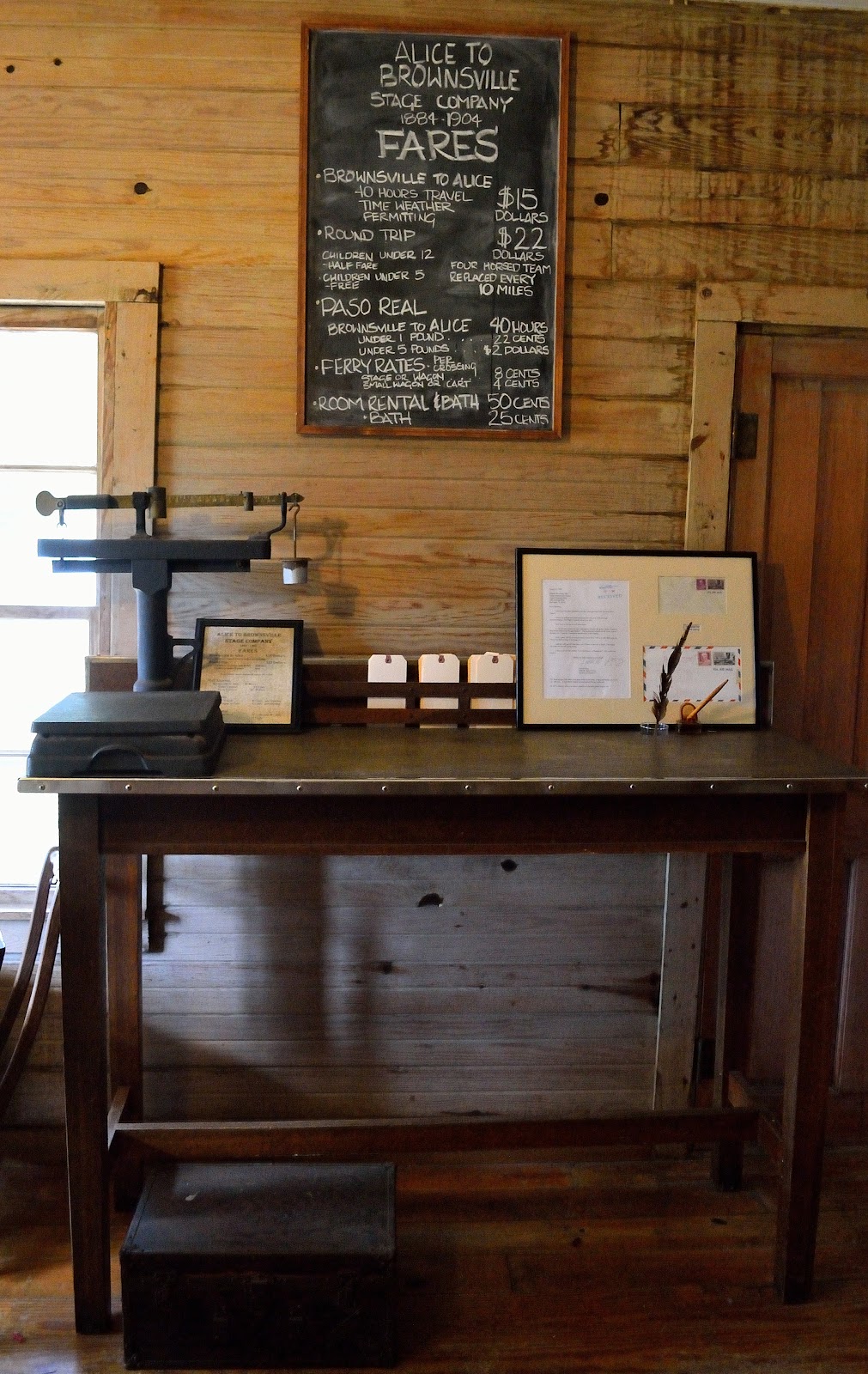
The last part of the museum was the Paso Real Stagecoach Inn. This is a replica built in 1978 by carpentry students using wood salvaged from the original. The original was built in 1850 on the Arroyo Colorodo River. It served as the way station for the stagecoach from Alice to Brownsville. Rooms cost 35-50 cents per night. Meals consisted of beef jerky, beans, tortillas, and milk. It was also the receiving place for Harlingen mail. In 1904 the railroad arrived making the way station obsolete.
This was a pretty cool museum all-in-all. Many of the artifacts were not under lock and key. They encouraged us to look in the early books or touch the bricks made by Hill himself. Can't say that about many places.
When our friends approached us about going to Mexico for the day, I must admit I was a little hesitant. Living in El Paso back in the day (my travelling nurse days) we would cross over into Juarez all the time. Today, the crime rate is so high I would never consider it. So what makes Nuevo Progreso so different. I'm not sure Progreso is any different from other Mexican border town. What is different is the amount of Winter Texans going across every day. As they say safety in numbers. Let me take you on our adventure to Progreso and you can decide for yourself but first here is a very short history of the town.
Progreso was originally named Las Flores after the ranch that once occupied the town site. During 1933 it was renamed Neuvo Progreso. Over the many years the Rio Grande River has moved around due to flooding. Progresso was originally on the U.S. side. A dam was built at Lake Falcon in 1940 to control the periodic flooding. About 500 acres of land was transferred back to Mexico including the land where the town sits today. During the 1950's medical doctors and dentists saw a need to help the community. Today, several hundred doctors, dentists, and pharmacists are present in Progreso.
As we start our adventure into Mexico we had already decided not to take our vehicles. Conveniently located on the U.S. side are two huge parking lots where you can park your vehicle for the day. Cost is $2. There is no security, you park at your own risk but I have not heard of a vehicle being stolen or broken into. If you do drive across there is usually a line up coming and going. Parking in Mexico is at a premium, not allot of places to safely park. I'm not sure but our vehicle insurance does not cover us for travel into Mexico. Another reason to leave it in the U.S.
As pedestrians walking across the bridge, the cost is .50 cents. We are still in the U.S. at this point. Canadian money is no good here. Paying at the turn style.
After paying our fees, we made the trek across the international bridge. Looking down we had a great view of the mighty Rio Grande River with the Border Patrol either driving along the banking or zooming down the river. You can also see "the wall" on the U.S. side. Yes, that is part of the wall that Trump, if elected will make Mexico pay for.
To enter Mexico we had to pay another .25 cents toll, not pesos but U.S. money. We were told prior to going not to bother doing a money exchange, Mexican vendors prefer U.S. dollars.
Our first impression, there are people everywhere. Street vendors, Winter Texans, kids, beggars, and so on. You can barely walk the streets without bumping into someone. Most of the action is along the main drag of Benito Juarez Ave. The side streets also have their share of activity. We stayed away from those areas.
As we walked along the street we were solicited by pharmacies selling every prescription drug on the market, from antibiotics to antidepressants to laxatives and everything in between. There had to be at least 100 dentists and pharmacies on the main street alone. You have to consider the main drag is only a half mile long, if that.
Mexico wouldn't be Mexico without a walking mariachi band. These guys would serenade you...for a price (in U.S. dollars of course).
There are a few places in Progreso known for good Mexican food...Arturo's which has been in business for 50 years and Angels which is on top of a four story building and gives a great view of the town. Walking around for a couple of hours we decided it was margarita time. When we crossed the border we noticed a small bar called Panchos Bar that looked like it was fun, so that is where we went.
We ordered a plate of nachos with cheese and jalapenos. They were the best or we were so hungry they tasted like the best. Sue and Bev were having a great time, I think it was the margarita talking.

It was a fun day all-in-all. Would we do it again, hell ya. However, we were constantly reminded that we were in a foreign country with military guards holding machine guns. No pictures of these guys. Lots and lots of begging on the streets by women with small children. I asked before taking this woman's picture, she was reluctant but then I showed her money and everything was good.
Leaving Mexico there was quite a pedestrian line up. We had a 20 minute wait to get back into the U.S.
Later that evening we decided to go out for supper at Longhorns Cattle Company Restaurant in Harlingen. They start with all you can eat charro soup. It was really good.

I order a soda because I was the designated driver. I was not expecting a jug of Coke but that's what I got. As they say everything is bigger in Texas.
Susan order the full rack of ribs and I ordered the three meat combo which included chicken, brisket, and ribs.
All the meat is mesquite smoked on an open flame. Some lucky person was getting a steak.
What a great day filled with exploring new places and eating great food. Life does not get any better.
When Susan and I have an opportunity to be out on the water we usually jump at the chance. While at the Rio Grand Valley RV Show one of the exhibitors was Breakaway Tours. For $40 they offered a tour which included the Port of Brownsville shipping channel, Brownsville Shrimp Basin, dolphin sightings, and birds. After a short discussion with our friends we decided it would be a great opportunity not to mention fun. So, I was left with the task of wheeling and dealing a better price. Not sure how that task was bestowed on me but it was. I was able to get the 4 hour boat trip down to $30 each. They were all happy so we signed up. Did I mention it included lunch which consisted of all you can eat shrimp. Oh, and all the beer you can drink. I knew this would be the highlight of our friend Bob's trip.
It was a typical Texas winter day bright, sunny, windy, and cool. That did not deterred any of us, we just dressed like Canadians.
The first interesting point was the start or end, depending on which way you're headed, was the intracoastal waterway. This waterway is a series of canals, inlets, bays, and rivers that runs the length of the eastern seaboard from Norfolk, VA to the Florida Keys and along the Gulf of Mexico from Apalachee Bay, FL to Brownsville, TX. The concept of an intracoastal waterway was first introduced in 1808. Travelling these navigational routes either by commercial barge or pleasure craft provides a safe environment away from the hazards of the open sea. The entire intracoastal waterway involves a journey of over 3,000 miles.
Shortly after leaving the dock the beer was flowing and everyone was having a good time. I abstained since drinking and boating do not go together for me. As we left the dock I was amazed at how shallow the water was. Some places it was a foot others 2 feet. However, the actual shipping channel has an authorized depth of 42 feet. The turning basin is 36 feet deep and has a width of 1,200 feet. Enough room for these big boys to turn around. This one was empty.
As we passed this big ship navigating the channel I was amazed at the tidal wave it was creating. No wonder all the birds were following it out to sea. It stirred up all the sea life creating an easy meal.
Our tour took us into the Shrimp Basin. This is where approximately 250 shrimp boats call home when they are not out shrimping in the Gulf. These larger boats are out to sea for 50-60 days at a time and away from home 220-240 days of the year. Each boat holds 10,000-20,000 gallons of diesel fuel. This Gulf shrimp boat was in dry dock.
Many of the boats stay in the water to be fixed or completely overhauled. Most of the boats are out in the Gulf fishing. When they are in we were told that they are 3 & 4 deep tied up at dockside.
After touring the shrimp basin our Captain took us out into the shipping channel where we had lunch which consisted of Gulf shrimp, corn, roasted potatoes, salad, buns, and more beer. The food was okay. Being out on a cool day everything was cold plus the shrimp was way overcooked.
As we continued on into the shipping channel we were told that taking pictures was a no-no. Something to do with the Border Patrol, the Harbour Patrol, and every other patrol you can think of. So I was able to take a picture before entering into the no-picture zone. All these old naval ships are being broken down for scrape metal including the aircraft carrier from the movie Top Gun, the USS Ranger. At this point my heart fell out of the boat. This is my all time favorite movie. To know that the ship no longer exists...the movie will never be the same. I'm sure I will get over this trauma. You can see her in the background. One big hunk of scrape, I'm crying inside.

On our return trip we entered the intracoastal waterway travelling the channel between Port Isabel and Long Island. The only way across to the gated community of Long Island is via a "swing bridge". The swing bridge in its closed position allows vehicle traffic to cross over the waterway onto the island. Open position vehicular traffic is stopped allowing water traffic to continue along the intracoastal waterway. The Long Island swing bridge has been operating continuously since 1950.
As our tour drew to an end we were able to see some dolphins playing in the water. If you have ever tried to take a picture of dolphins you can understand why there are no pictures. Most of the time you get a whole lot of nothing. Here's a picture of South Padre Island skyline somewhere there's a dolphin under water.