Saturday, June 30, 2018

Day - 33 Tok, AK

We left Chicken early in the morning knowing that it was going to be a very slow drive. Even though they say the road is paved it’s more broken pavement, frost heaves, gravel, and pot holes all mixed together. At times the trailer was moving up and down so much it almost took me off the road. But the worst part is it started raining and everything went downhill from there. As we climbed into the hills we started getting socked in with low cloud cover. What made everything worse, you couldn’t see the road at times nor the potholes. That slowed things down to a crawl. It's like the movie...The Good, The Bad, and The Ugly.
The Good
The Bad
...and The Ugly

The further we travelled the road got a little better but the weather did not. It continued to rain most of the way to Tok.
We finally reached our destination of Tok, Alaska. We got checked into the campground, found our sites, got all hooked up, and now it's time to see some husky puppies...or I thought.
Let me talk about Tok before anything else. Tok is often referred to as the "Gateway to Alaska" because it is the first major community you meet in Alaska when heading north. The area was originally settled by the Athabascan Indians. The name "Tok" is derived from the Athabascan word meaning "water". The town originated as an Alaska Road Commission camp for the construction and maintenance of the Alaska (Alcan) Highway in the 1942.

Today the town boosts a population of 1250 year round residence. Tok is also known as the "Sled Dog Capital of Alaska" which is apparent by the number of dog kennels in the area. And that is where our first stop is going to be...or I thought.

After I got things hooked up, Susan calls me from inside the rig saying "the fridge is not working". That's never a good sign. So long story short, I investigate and yes she is right it's not working. After an hour of checking this, that, and all points inbetween, I figured out it was the temperature monitor control. Nothing I can do, it needs a professional. So we take everything out of the fridge and freezer and divvy it up between Kathy's and Bev's fridge. What great friends. 

So, we go to a place called Burnt Paws to see husky puppies and strike two, no puppies. She informed us that there are puppies at some of the kennels but know one will let you see them. Its because they are still young and the mushers want to form that one on one bond with them. I understand all too well. So back home we go. The weather is just to crappy to do anything else. As far as the fridge goes I will keep you posted.

Friday, June 29, 2018

Chicken, AK Part 2

The history of Chicken is rich and began with the discovery of gold in 1886 on Franklin Creek. A major discovery was made ten years later in 1896 on Upper Chicken Creek. It is said that 700 miners worked the area between 1896 and 1898. In 1903 a post office was established for a population of 400. Today there's a new post office but the population has dwindled to 3 in the winter and approximately 27 in the summer.

How did Chicken get it's name? Well, as the story is told the town was named by early miners. They actually wanted to name the town ptarmigan but were unable to spell it so they settled on chicken. The common name for ptarmigan in the north is chicken. 

It seems that everything is chicken in Chicken. There's a total of three businesses all with their own take on these feathered creatures.

 
 The Pedro Dredge was manufactured in San Francisco in 1938. It was shipped to Pedro Creek which is 15 miles north of Fairbanks, AK. It was in operation at Pedro Creek until 1958. It was moved to Chicken Creek and worked from 1959 to 1967. The Pedro Dredge produced around 58,000 oz of gold during it's time on Chicken Creek. This would equate to approximately 50 million dollars today. The dredge was listed as a National Historic Site in 2006.
Chicken is not only well known for gold discovery but also for being the home of the late Anne Hobbs Purdy, whose story is told in the book "Tisha".  The book chronicles Anne Purdy's life in 1927 in the Alaskan wilderness as a nineteen years teacher. A young native child could not say teacher so he called her "Tisha". In the old historic town of Chicken many of the original buildings are still standing...but just barely. They are all in such disrepair. 
The tour of old historic Chicken was amazing and informative. As we were walking toward and away from the town we had to constantly be on the lookout for moose and bears. Moose have young right now so they can be very dangerous. Grizzlies are alway in the area. I did make time to stop and smell the flowers. 

Thursday, June 28, 2018

Day 31 - 32 Chicken, Alaska

After three wonderful days in Dawson, it was time to move on. Our next destination is Chicken, Alaska. But first we have to conquer “Top of the World Highway”. We left Dawson around 8:30 and headed for the ferry. The Yukon government operates a free ferry across the Yukon River called the “George Black”. The ferry is seasonal, it usually starts mid-May and stops mid-October depending on spring break-up and fall freeze-up. The ferry operates 24 hours a day 7 days a week. It shuts down for two hours on Thursdays between 5 – 7 am for servicing.

Ted and Bev had to diesel up so they left early and got to the ferry before us. We watched them cross then it was our turn.
There was quite a dip in the road to get on and off the ferry. Once we got over that it was clear sailing to the other side. The whole ride took 10 minutes and that included loading and unloading. As we crossed the river, looking back at downtown Dawson, the view was amazing.

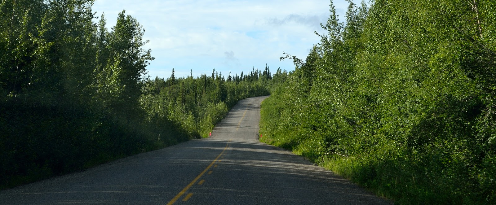
As soon as you are clear of the ferry ramp the road starts a steady climb for 14km or 8 miles. Most of the grade is between 7 – 9 percent uphill climb. This portion of the road is paved with very few potholes. Once we all got to the top there’s a parking area. We stopped to take in the moment.

Within a km of leaving the rest area we ran into our first dirt road which was hard packed and had very few potholes. Not bad at all. It’s a beautiful sunny day, no rain all is good.
No sooner I said about the rain we could see rain closing in on us. When we were in Dawson all these vehicles would be coming into the campground absolutely covered in dirt and mud. I thought they were on the Dempster Hwy. Wrong, they came from this very road. It started to rain and within 5 minutes my truck and rig looked like everyone else’s. The problem is the road gets quite narrow and extremely slippery when it rains. To compound that the shoulders are soft, there’s no guardrails, and you’re trying to avoid potholes and washboard.
If that wasn’t bad enough, we climbed so high there was snow still on the side of the road. I kept reminding Susan that if we went off the road we would not stop until we hit the river below. Which is a long, long way down. I won’t tell you what she said back to me.
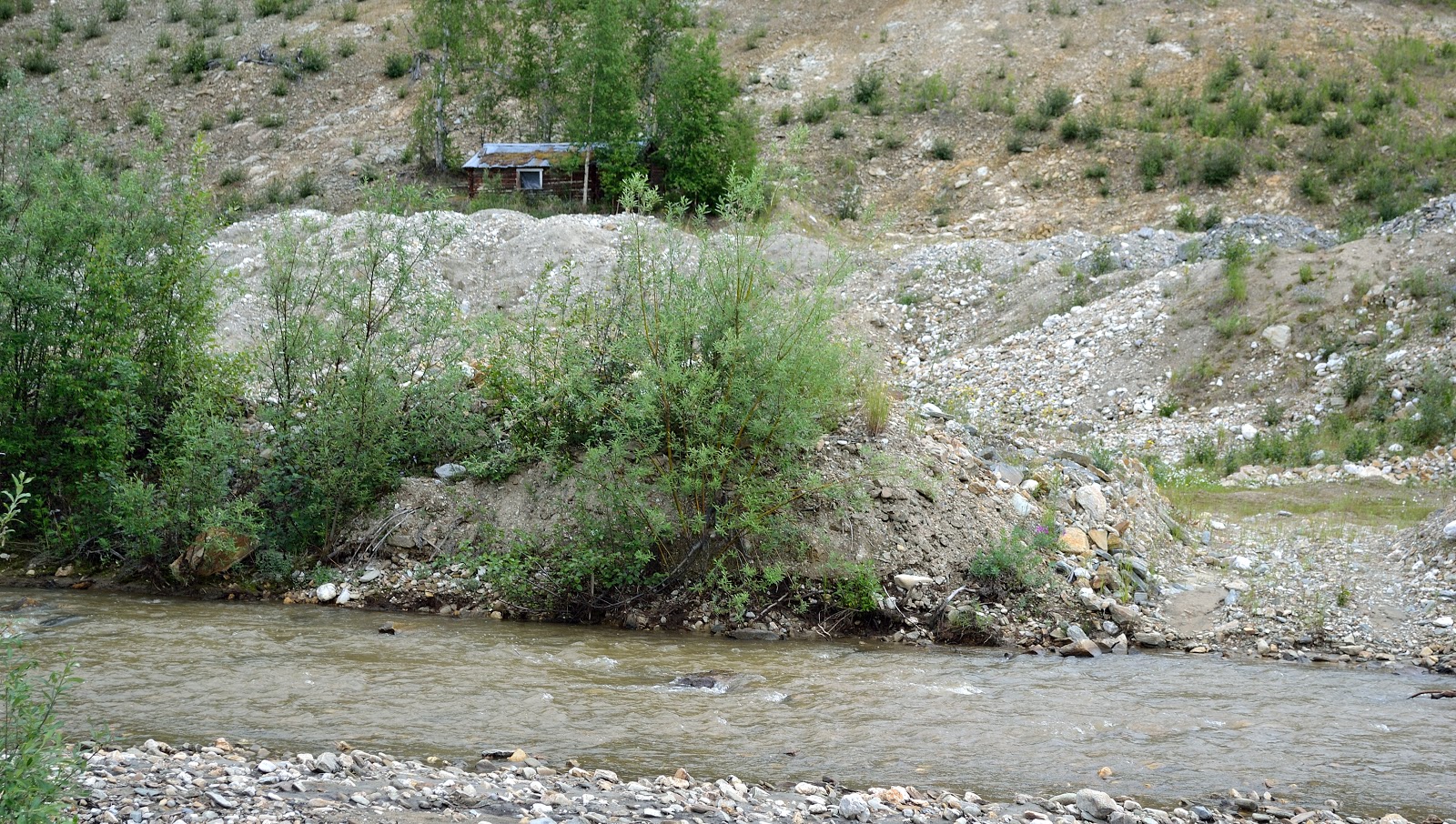
We stopped at the 87 km or 54 mile marker just to catch our breath. The Top of The World Highway is really two highways, the Yukon Hwy 9 in Canada and the Taylor Highway 5 in Alaska. As we were stretching our legs we noticed an old fallin’ down log house. If walls could talk. This old sod-roofed cabin was the supply and stopping place for a transportation company. The views from way up here were spectacular. Just to give another perspective Dawson elevation is 320 metres or 1,050 feet. The highest point we reached on the highway is 1,376 metres or 4,515 feet. Virtually all the Top of the World Highway runs above the tree line. The only civilization that you run into is at the border crossing. If you have vehicle problems it will take a long time to get help.
As we came around a curve we saw the border crossing. Civilization or we thought. The U.S. & Canada Customs is at 105.7 km or 65.7 miles. Three people are stationed at this crossing, two on the Canadian side and one on the US side. The US customs guard was really nice. The only thing they took was my oranges which happened to be a product of Spain. We waited down the road for the others to pass customs. And again the view was amazing. It has taken us over two and a half hours to travel 65 miles. Their Welcome to Alaska sign must have blown down in the winter. It’s too hard and probably too costly to get equipment up here to right it.
As we leave the border crossing we are a little spoiled. The road is beautifully paved. That was short lived as it turned to gravel and pot holes...again. We come to Jack Wade Junction, go to the right and the road takes you to Eagle, AK. Go to the left and your headed for Chicken, AK. That is where we are headed. 

We continued on for another half hour then it was time for a bathroom break. The road is somewhat paved but not really. There are large pot holes and dips from frost heaves not to mention the hairpin turns, no shoulders or guardrails.
We came around a curve and sure enough there it was, the community, town, or whatever you want to call it ...Chicken, AK. 
There are two campgrounds in Chicken, each offering something a little different. We chose to stay at Chicken Gold Camp & Outpost. 
Even though this area is extremely remote, more and more travellers are daring the Top of the World Highway. Two large caravans pulled out of the campground just prior to us arriving. Just to put it into perspective, there is no city water, sewer, or electric service. There is no cell service way up here. We had 20 amp electric service at our site and that was generated from large diesel generators. It was the best 20 amp service I have ever had. So, why Chicken. I'm still asking myself that same question.  

Wednesday, June 27, 2018

Day 30 - It's All About The Gold - Dawson City, YK

One million people, it is said laid plans to go to the Klondike. One hundred thousand actually set off and about thirty thousand made it. What was moose pasture and a fish camp was transformed into a metropolis in two years. Dawson grew slowly throughout the winter of 189, but once the Yukon River thawed in May 1898, boats arrived by the hundreds at all hours of the day or night. Dawson City became the largest city north of Seattle and west of Winnipeg.

Gold seekers heading to the Klondike in 1898 were required to pack and carry their goods over the Chilcoot Pass. The list of supplies required for each man included 400 pounds of flour, 100 pounds of beans, and 100 pounds of sugar. These are just a few of the items they had to carry. The average man took about 40 trips to haul his supplies to Bennett. That’s over icy trails, through blizzards and sub-zero conditions, not to mention the Chilcoot Pass Summit.

During a global depression and the associated widespread unemployment in the 1890’s thousands of men and a few hundred women joined the Klondike Gold Rush. Most seekers found no gold but the prospect of sudden riches was not all that mattered. The Klondike represented escape from the humdrum life and the adventure of a new frontier.

Not long after gold was discovered in the Klondike, dredges started showing up in the Yukon. One of two dozen dredges worked this area was Dredge No. 4 which rest on Claim No. 17 below Discovery on Bonanza Creek near the spot where it ceased operations in 1959. It was the largest wooden hull, bucket-line dredge in North America.
To get gold from the ground, the bucket line dug down to bedrock bringing gravel up to the hopper. Gold is heavy, so gravity sorted it from the waste as it passed through the trammel and sluice. The sluice worked like gold pans, trapping the gold in the riffles and coconut matting then sending the waste out the stacker.
Dredge No. 4 worked its way up the Klondike Valley into Hunker Creek. The ground at the mouth of Hunker Creek was so rich the dredge produced as much as 800 ounces of gold in a single day. Over 46 years, Dredge No. 4 recovered eight metric tons of gold.
All placer (loose) gold mining required two things: water and gravity. Inside the dredge, a large pipeline sprayed water into the trammel to wash the smaller and heavier gold bearing gravel through the holes into the sluice tables. More water washed over the sluice tables and washed away all but the heavier gold particles. 

Before the Bonanza Creek discovery, the first major find of coarse gold flakes and nuggets came on Forty Mile River in 1886. Prospectors travelled up the Klondike River but they overlooked the rich pay streaks of the tributaries.

In July 1894, Robert Henderson started prospecting the tributaries of Indian Creek and in 1896 started mining on Gold Bottom Creek in the Klondike Drainage. Henderson met George Carmack at a fish camp and invited him to visit his workings at Gold Bottom. About 20 days later George Carmack, Skookum Jim, and Dawson Charlie travelled up Bonanza Creek to visit Henderson and found some gold flakes. The three men staked claims at the richest spot they found. George went to Forty Mile to record them. No one felt the need to tell Henderson and by the time he found out all the rich ground was staked. While Carmack was recording the claims, Skookum Jim was credited with sinking the first post on Bonanza Creek. 

And this is where it all happened. The picture is of Skookum (far left), George Carmack (center), and Dawson Charlie (far right). There’s a great one kilometer trail that talks about the discovery of gold and how mining has evolved over the years. You can even site at the site where the first gold discovery was made.
Bonanza Creek
An early sluice was an inclined wooden box with obstacles (riffles) to catch the heavy gold as water washed gravel and sand down its length.
There is still evidence today of old mining claims along Bonanza Creek. 
In saying that the area is still actively mined north of Bonanza Creek as evidence of the TV show Gold Rush. We watch the show all the time. Susan and I were getting into our truck and who drives by but Parker from Gold Rush. Sorry no pictures happened way to fast.

So what do you do when you have read all the history on the Klondike and seen Discovery Claim, well you try it for yourself at Claim 33. We didn’t strike it rich but let’s say we struck gold and had a great time.
After striking it rich we all thought we were pros at this gold mining business. Claim 6 is a free claim that anyone can pan for gold at any time with a few limitations. So with pans and shovel in hand away we go.
We didn’t find any gold but had a great time. 

Before departing Dawson I had to find my cousin. After supper I was on a mission, and sure enough I found him. That made my trip to Dawson even that much better. It was just bad we couldn’t spend more time together. He was working, I was leaving.

Tuesday, June 26, 2018

Day 29 - More Dawson City

We started our day souvenir shopping then went to see the S.S. Keno which is a National Historic Site. Constructed in 1922, the S.S. Keno was the smallest of the British Yukon Navigation Company’s fleet. Her primary job was to transport silver ore from Mayo mining district to the Yukon River at Stewart Crossing. However in the spring and fall when the Yukon River is at its lowest the S.S. Keno with its shallow draft made the first and last trips of the season from Dawson to Whitehorse. This sternwheeler provided a vital link to the outside world for those living in Dawson City. On her last trip in 1960 the S.S. Keno was brought back down river from Whitehorse to rest in her current location on Dawson’s waterfront.
Each fall, the freezing river stopped all sternwheeler travel and the ships were hauled ashore using capstans. Sternwheelers, some over 700 tons were hauled ashore by labouring horses.
Another stop we made was at the original cabin of poet Robert Service. Parks Canada now owns this building and offers tours and readings of his work.
In 1897 at the age of 21, Jack London left San Francisco to join the Klondike Gold Rush. He hiked the Chilcoot Pass, and as a skilled boatman navigated Miles Canyon and the Whitehorse Rapids. He travelled the Yukon River to find himself in Dawson for the summer and winter. He tried his hand at prospecting but never found any gold. Penniless and sick he returned to California. The Klondike had a major influence on his writing with novels like The Call of the Wild and White Fang. This site contains some of the logs that were used in the original Jack London cabin.
The massive scar on the hillside to the north is a prehistoric landslide, and not the result of mining activity. The Dawson City landslide, known locally as Moosehide Slide is a dominant feature of Dawson’s cityscape. For centuries, spotting Moosehide Slide has marked the ed of the journey for people travelling down the Yukon River to the Klondike.
It’s hard being a tourist, we seem to be hungry allot. So why fight it. We went out for an early supper late lunch. We chose Sourdough Joes Restaurant. The food was great. Then we went next door for ice cream.
Not that we needed more to eat, but we stopped anyway at the local bakery because it was just next door to the ice cream place. Yes, we couldn’t resist. We picked up a couple of cheese & pepper biscuits and Susan wanted a couple of sticky buns. Fifteen dollars later we walked out, yes things are more expensive here than back home. Do we care…nope because it’s all about the adventure.
Across the road is a tribute statue to the miners who staked the first claims on Bonanza and Eldorado Creek back in 1896.
The Yukon River is the third longest river in North America 3185 km or 1980 miles, after the Mississippi and Mackenzie. It drains and immense basin of more than 840,000 square kilometres or 325,000 square miles, an area 25% larger than Texas or Alberta.
The Yukon River was named by the Hudson’s Bay Co. trader John Bell in 1846. “Youcon” was Bell’s version which means “great river” in Athabaskan, the people of Northern Yukon. If you so desire you can take a narrated old fashion paddlewheeler cruise on the Yukon River. We chose not to at this point, not enough time.
We decided to spend an evening out at Diamond Tooth Gerties Gambling Hall. Susan and I gambled a little (Susan more than me) but the real fun was the live entertainment. It featured Diamond Tooth Gertie and her Can-Can Girls. The first show was at 8:30. There’s also a midnight show but we all knew we would be asleep. The show was sooooo much fun.
Its midnight and the sun is shining just as if it was 12 noon. No wonder I’m finding it hard to sleep.