Friday, January 31, 2014

Sabino Canyon, AZ

The Santa Catalina Mountain range began their formation about twelve thousand years ago, the same time giant Mammoths roamed this area. Today we are roaming the area called Sabino Canyon.

Sabino Canyon is part of the Coronado National Forest in Tucson, Arizona. Arriving at the park we paid a $5.00 vehicle entrance fee, found a parking spot, and planned our trip. We decided on the narrated shuttle bus ride ($8.00 each) up the canyon. There's nine stops at which time you can get off or on at any time. However, if you come all the way back down on the shuttle you can't go back up. Now we know the rules away we go.
Green is the start, Yellow is the tram route, Red is the end
As we were riding the tram up the canyon I was thinking I would rather have walked the almost 4 miles to the turnaround. The tram seats were so hard and uncomfortable you felt every bump. I'm definitely not taking it back down. I hope Susan feels the same way.

Finally at the top and what a view. Susan was on board with walking back, until she got too tired then we would pick up the tram. But for now I am just soaking in the beauty and serenity.
The turnaround point for the tram at the top
With camera in hand, a lunch bag over my shoulder, and binoculars around my neck, away we go. As we started our descent down the canyon we met many people walking up then passing us going back down. Now that's a workout 8 miles round trip.

In 1887 an earthquake centered in northern Mexico caused massive rocks to crash down and come to rest on the valley floor.
Valley Floor
In the 1930's CCC workers built bridges and 4 miles of road through the canyon into the mountains. The intent was to build a road to Mt Lemmon but the terrain was too difficult to proceed. Today the road ascends from 2800 feet at the visitors center to 3300 feet at the tram turnaround.
Susan walking over one of nine stone bridges
 
The water is very, very cold

As we continued down the road the tram passed us numerous times. Susan being the real trooper wanted to keep walking. Trams first started operating in 1978. From that point onward vehicles were restricted.
Beautiful Saguaros and rock formations in the canyon
Thimble Peak in the background
Throughout the park there are several hundreds of miles of trails from easy to extremely difficult. There is also camping in the backcountry but beware this is mountain lion and bear country. We saw many many signs indicating so. The only wildlife we encountered along the route were several different birds. We decided to have lunch at stop #3. We were joined by this beautiful guy.
Male Northern Cardinal
 
Sitting there we couldn't help but take in the beauty and quietness of our surroundings. I wanted to stay longer, not a person around, no cars whizzing, it was sooooo peaceful.
A wash from when it rains
Two and a half hours later we get back to the visitors center. Susan still has a smile on her face but says she's tired. That's okay so am I. What a great hike.
A large flowering Barrel Cactus
 

Tuesday, January 28, 2014

Saguaro National Park


Located in the heart of the Sonoran Desert and approximately 55 miles north of the Mexican border is the Saguaro National Park. Saguaro National Park consists of two separate areas, Saguaro west or Tucson Mountain District (TMD) and Saguaro east or Rincon Mountain District (RMD). Together there is over 91,000 acres of desert life. The two are separated by the city of Tucson and 1 million people.

What a decision, which one do we visit and what is the difference between them. We are camped closer to RMD so that is where we decided to start our cacti adventure. Both parks have several miles of hiking trails some short and easy other very long and strenuous. Our trek today is by truck on the 8 mile Cactus Forest Loop drive.
Saguaro National Park - Rincon Mountain District
Saguaro National Park did not always look the way it does today. During the 1880's the railroad came to Tucson bringing more people. With more people can the need for an increase in land for cattle grazing. This activity caused young seedlings to be trampled resulting in their destruction. The elimination of cattle grazing as late as 1979 has caused a rebirth in the cactus forest.
Several different types of cactus grow here
Saguaros grow very slowly. It starts as a black shiny seed the size of a pinhead. One saguaro can produce 40 million seeds in it's lifetime. After one year a seedling may be 1/4 inch tall.
After 15 years the saguaro may barely reach 12 inches tall.
After 75 years the saguaro begins to sprout it's first branches or arms. These arms start as prickly balls on the sides of the saguaro.
The start of arms
Saguaros can reach 50 feet tall, have several arms, and weigh over 8 tons, of which 90% is water.


Saguaro cactus are supported by a strong framework of long woody ribs. These become apparent after a cactus dies. These giant cacti can live 150 years.
Ribs are apparent on this dead saguaro
Saguaro National Park is home to several other types of cactus and plant life. Susan decided to get up close and personal with this cactus.
Fish-hook barrel cactus
Staghorn cholla
Chain-fruit cholla
Desert animals are well adapted to life in these harsh conditions. They include the desert tortoise, Gila monsters, jackrabbits, javelinas, Gambel's quail, and Western diamondback rattlesnakes. Great I'm not telling Susan about that one, she would never get out of the truck.
Harris's Antelope Squirrel
As we continued our drive around the park we noticed Saguaros growing on top of rocks.
Before leaving the park we got to see a rare crested or cristate saguaro. The growing cactus produces a fan-like tip giving it an unusual look. Scientists are unsure as to the reason this deformity occurs.
Crested Saguaro

Saturday, January 25, 2014

Bisbee, AZ

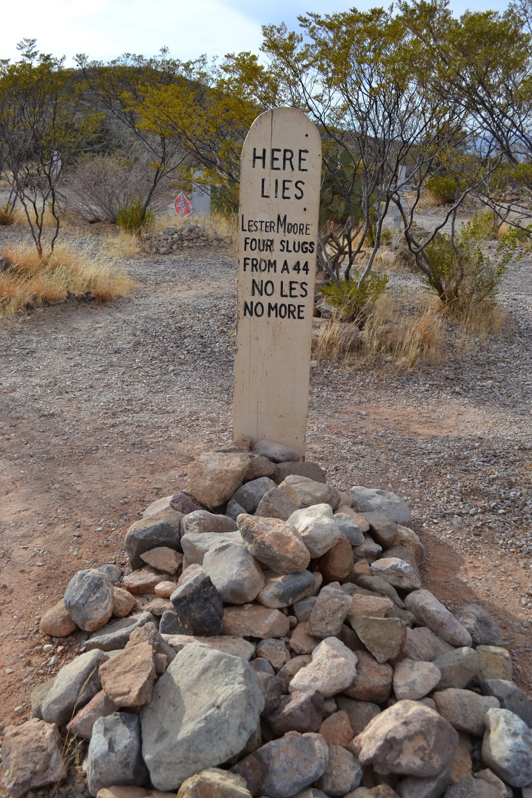
It's a gorgeous day not a cloud in the sky so we decided to spend our last day in Huachuca City sightseeing. Where to go, where to go? Nestled amongst the Mule Mountains is a picturesque little town called Bisbee, AZ. Interested in finding out more, this is where are adventures will take us.
Bisbee sits at 5300 feet and was founded in 1880. It became known as "The Queen of the Copper Camps. Before the mines closed in 1975, Bisbee produced metal worth $6.1 billion (at 1975 rates). Got your interest, it did mine. 

Much of Bisbee housing is built on hillsides which makes getting around difficult. The streets were built for horse and buggy not Dodge Ram 4x4's, so we opted to walk the town.
Residential area above the town
As we drove into Bisbee and climbed in elevation we left the desert cactus behind for trees and red coloured stone and soil.
Lots of trees very few cactus
As we walked around Bisbee you can't help but see the evidence of a once booming mining town. In almost 100 years of production it is estimated that Bisbee mines produced over 8 billion lbs of copper, 2.8 million ounces of gold, 77 million ounces of silver, 304 million lbs of lead, and 372 million lbs of zinc. OMG that's a lot of rock to move. 

Abandoned mining building

Old abandoned mine on side of road
I wanted to take the tour of Queen Mine, Susan not so much. She opted to stay above ground and watch the video.

Queen Mine
The big producer of copper back in the day was Phelps Dodge Corporation. They closed the mines in 1975 leaving Bisbee a shadow of it's former self. The mayor at the time suggested opening mine tours in the world-famous Queen Mine. The tours opened in 1976 with men that have worked in the mines leading the tours.
Getting outfitted for the tour
Everyone that enters the mine gets outfitted with a hard hat, yellow slicker, light, and a tag.
My mining buddy if I get lost
Am I nervous heck no just excited about seeing what's down there. Our tour guide gave us all the information we needed just in case...... In case of what?? A cave in, someone losses a helmet, or you get lost in the mine.
Away we go, we ride on a train, I love trains
We stop frequently along the trip so the guide can tell us how  deep we are in the mine. Also we get off the train to experience conditions that miners worked in.
Older style drills used
Setting dynamite charges

Newer drill used today in mines
Now I understand the reason for everyone having a light. It's not so much in case you get lost, it's because it is so dark down there. There's virtually no external lighting.
 
Now you know the big question for the whole trip is going to come up. Back in the day where did the miners go to the bathroom. Well here it is......looks good to me, if you have to go you have to go. Interesting,  a two seater, share anyone!
The guide told us some good bathroom stories 
WOW, what an experience, I couldn't imagine working in that type of environment. It was sooooooo dusty and we weren't mining. After handing in all my equipment we decided to go for lunch, but first I wanted to try my luck at breaking open a rock.
Me and my pet rock
Lunch was at a nice restaurant in downtown Bisbee. The building was built way back in the day and the people were super friendly. Yes of course I ordered a burger.
Burger and slaw can't get any better than that
After lunch we decided to head out of town the opposite way we came in. I'm glad we did because what an experience. Firstly, we came upon this massive and I mean massive open pit mine called the Lavender Pit. From 1950 to 1974 when it closed, the Lavender Pit yielded 86 million tons of ore. One of the by-products was turquoise. Bisbee turquoise, also called Bisbee Blue is amongst the finest in the world.
This pit was monstrous
A short distance down the road from the Lavender Pit I thought we had entered a time warp. Once a booming town of activity now Lowell, AZ is a mere shell of it's former self. The Lavender Pit excavated most the downtown area leaving one main street. That is where we found ourselves, mouths open thinking we travelled back in time.
Old signs old cars on the street
Old military vehicles
Check out the old greyhound bus
We saw other people wandering around looking the same way we did, almost lost for words. What a great day.

Wednesday, January 22, 2014

Tombstone, AZ

Coined as the town too tough to die, Tombstone AZ  reached its greatest and then faded in eight short years. Today it is a very popular tourist attraction and that is where our quest for worldly knowledge takes us.

In 1877 this wild mining town owes its beginning to Ed Schieffelin. He was warned several time by friends and military troops because of the hostile Apaches that all he would find would be his own tombstone. Hence that is how the town got it's name.

Pictures of Schieffelin and his belongings
Schieffelin Hall built in 1881 by Ed's brother was a first class opera house, theater, and meeting place for Tombstone residents.
Schieffelin Hall

As the population reached 10,000 in 1881 the town started to expand. Within two years Tombstone had several building including saloons, dancing halls, churches, and brothels.
City Hall - 1882
While gentlemen and ladies attended operas at Schieffelin Hall, miners and cowboys watched shows at the Bird Cage Theater. At the time it was named the wildest and the most wicked place in Tombstone. Today this is the only place in Tombstone that has never been renovated, it stands the same way today as it did in 1881 bullet holes included. 
Bird Cage Theater - 1881
C.S. Fly and his wife Mollie were frontier photographers arriving in town in 1879. Although the gunfight at O.K. Corral occurred beside their studio it was never photographed, cameras of the day did not allow for quick action.
C.S. Fly Studio
In the 1880's prostitution was perfectly legal in Arizona. Small buildings called "cribs" lined the streets in Tombstone. Most cribs looked the same, so the ladies would paint their name on the door so they could be easily found. Wyatt Earp's second wife and Doc Holliday's girlfriend both worked in this profession.   
A typical looking crib
The city license below was dated in 1881 in the amount of $4.30 for the business "House of Ill Fame". Note on the side, payment refused and signed by Wyatt Earp.

City License for "House of Ill Fame"
As we walked the streets (in a good way) of Tombstone, on several occasions we saw Wyatt, Virgil, and Morgan Earp along with Doc Holliday and his girlfriend.

Heading for the gunfight at O.K. Corral
As Tombstone grew in population in 1882 the stylish Cochise County Courthouse was built at a cost of $50,000. It housed the sheriff office, courtroom, and the jail in the back. Susan and I both thought this was the best place for Tombstone history and information. 
Cochise County Courthouse - 1882
John F Ross Attorney's Office - 1914
Courtroom
The gallows outside the courtroom
All this sightseeing found Susan and myself hungry so we decided on The Crystal Palace Saloon. Original known as the Golden Eagle Brewing Company it was one of the first saloons in Tombstone.
Crystal Palace Saloon - 1879
We saw Morgan Earp and Doc Holliday heading there for  some vittles so we figured it had to be good.
Morgan Earp & Doc Holliday
I love my burgers
Our last stop of the day was Boot Hill Graveyard. "Boot Hill" got it's name due to the many that are buried there died violently with their boots on.
Boot Hill Graveyard
The entrance door
The most notable grave site is Tom & Frank McLaury and Billy Clayton who were killed in the shootout at the O.K. Corral.
Billy Clanton, Frank McLaury, & Tom McLaury grave site
 Here are some of the more colourful grave markers we saw.